Extreme Waves (2006)
Chapter: 9 Freaks, Rogues, and Giants
9
Freaks, Rogues, and Giants
On March 2, 2001, the cruise ship Caledonian Star, heading home from a cruise in Antarctic waters, found itself in gale-force winds. The Caledonian Star is a rugged ship, specially designed and strengthened for service in the rough waters and rough weather of the Southern Ocean. At 5:30 P.M., the first officer, standing watch on the bridge, saw something totally out of the ordinary—something beyond anything he’d ever experienced before. In a BBC broadcast a year after the event, he was quoted as saying that out of nowhere a wave appeared—a wave that seemed to be twice as high as the other waves the vessel was experiencing. Later estimates, based on the height of the ship’s bridge above the waterline, indicated that the wave was 98 feet high. The wave approached the vessel at an angle of 30 degrees on the starboard bow, preceded by a deep trough.
The Caledonian Star nosedived into the trough and tilted to one side, throwing passengers against the bulkheads as the bow of the vessel buried itself in a mountain of green water. The helmsman was unable to see the top of the wave from his position on the bridge. Both he and the first officer stated that they dove for cover as a wall of water crashed through the windows and washed them away from the ship’s
controls. They described being completely submerged under water; tossed about in a maelstrom of cushions, books, and debris; and literally swimming back to seize control of the ship. The saltwater wreaked havoc with the ship’s instrumentation, wiping out radar, gyro compasses, some of the radio communication equipment, the depth sounders, and sonar.
Fortunately, the engines remained in operation and the steering was not affected, so the crew was able to regain control of the vessel and keep it from turning parallel to the seas where it might have rolled and suffered more serious damage. Crewmen were able to board up the broken windows, and the vessel returned to port without further incident.1
CAUSES AND CHARACTERISTICS OF ROGUE WAVES
The earliest seafarers experienced huge waves that swamped their frail vessels, in most cases leaving no survivors. The numerous wrecks in the Mediterranean, their hulks replete with wine bottles and other cargo, are mute testimony to these disasters. The story of Jason and his quest for the Golden Fleece predates the Trojan War and would have been known to Homer and even to Odysseus had he been an actual person. When Apollonius Rhodius rewrote the ancient story in 300 B.C., he was just retelling what the ancient Greeks had known for centuries—that the sea could be very dangerous. Only by invoking the favor of the gods, or by skillful piloting, did the Argonauts survive, as this passage relates:
… [They] set off under sail through the eddying Bosporus. There a monstrous wave rears up in front of their ship like a soaring mountain; it threatens to crush down as it towers high over the clouds. You would imagine that there is no escape from a miserable fate, as the violent wave hangs like a cloud over the middle of the ship….2
The language here is telling. Note the key words: “like a soaring mountain,” “towers high over the clouds,” “hangs like a cloud over the middle of the ship.” Compare this to Captain Warwick’s description later in this chapter of what happened to Queen Elizabeth 2, as he told his story nearly 4,000 years after the Argonaut’s tale. Some of the “mys-
teries” of the sea are not so mysterious; we’ve just chosen to ignore them. Until recent times, many such reports were dismissed as the products of overly active imaginations or as exaggerated reports of actual phenomena. New research suggests otherwise.
What are rogue waves like? Until recently, there was no generally accepted definition of what constitutes an extreme wave—as noted by the fact that oceanic literature refers to them variously as freaks, rogues, or giants. Today, a definition of an extreme wave is one that is 2.2 to 2.4 times higher than the significant wave height, although some scientists might say that an extreme wave is any unusually large wave.3 Extreme waves may occur singly or in groups of several waves. They differ from ordinary waves in several other ways, too. They are asymmetrical, resembling the profile of a wave that is breaking or about to break, and may be preceded or followed by a deep trough.
This description illustrates one of the important features of extreme waves: the crest height is much greater than the depth to the trough of the wave. In the mathematician’s vernacular, such waves are nonlinear. Moreover, extreme waves are frequently much steeper—say, on the order of two or three times—than the prevailing waves. These characteristics—a steep wall of water rising several times higher than the usual waves, preceded or followed by a deep trough—are among the reasons such waves are dangerous to supercarriers as long as two football fields and are likely to be disastrous to fishing boats and yachts. Their occurrence is so far largely unpredictable, and they can arise suddenly, even in moderate seas. In some cases we have a good idea about the conditions that can give rise to an extreme wave—an example being interaction of swell and strong currents—but in other instances researchers are not sure. The sea state and duration are believed to be important factors.
Even worse than one extreme wave is several. This condition is called “the Three Sisters,” since there have been a number of cases in which three successive extreme waves have been reported.
Any sailor who has sailed the ocean has most likely experienced a rogue wave, if you define “rogue” to signify a random wave at least 2.2 times as high as the significant waves in the sea at that time. Unless the seas were running exceptionally high and the wave presented a real
danger to the vessel, such a wave was probably noted and then quickly forgotten as the voyage progressed.
I’ve experienced several such waves, once on the same trip to Catalina mentioned in Chapter 4, except that we were outbound for the island. There had been several storms in the Southern California area the previous week, but by the time we sailed the weather had settled down and seas were the usual 2- to 3-foot-high northwesterly swell. The trip was uneventful until we were about two-thirds of the way across the San Pedro Channel on our way to the island, when I saw a larger than usual wave—around 6 feet high. I turned Dreams to take it at 30 degrees. The bow rose sharply and then slammed down into the trough, sending a large spray of water into the air on both sides of the bow. Dishes and pots and pans rattled in the galley lockers. The boat shuddered, regained momentum, and we continued on our way. Someone asked, “What was that?” Oh, just a wave, I replied. I promptly forgot about the incident until I was reminded of it by Nancy Smith, while writing this book.
There are several schools of thought regarding the formation of extreme waves. Some scientists are exploring sophisticated theoretical models in an effort to better understand the underlying physics of extreme waves so that conditions that give rise to them can be predicted. At the other end of the spectrum are those who think that extreme waves simply arise as a consequence of the randomness of the sea; there are no unusual physics involved. Consequently a great deal of research is being performed to better understand how extreme waves are formed. For example, it may be that nonlinear effects, multidirectional effects (such as crossing waves), focusing, or other phenomena can cause them. See Appendix A for a brief description of these efforts.
I believe there are at least four ways in which extreme waves can be produced: (1) the interaction of strong currents with storm waves moving in the opposite direction; (2) hurricanes and storms; (3) shoaling and pile-up of waves in shallow depths along the continental shelves, the North Sea, and other shallow-water seas; and (4) seas in which constructive interference (superposition) of random waves suddenly generates a wave much higher than the average.
STRONG CURRENTS
One area where giant waves have sunk a disproportionate number of ships is the Agulhas Current along the east coast of South Africa (see Plate 12). This area has been known since ancient times as a dangerous coast and was avoided by early Arab sailors who traversed the Indian Ocean before Portuguese navigators finally rounded the Cape of Good Hope in the 1500s. Storm-produced waves originating in the Southern Ocean run up against the southbound Agulhas Current, creating extreme waves. Since 1990, at least 20 ships have been devastated by rogue waves there. Researchers say that the Agulhas waves can be 66 to 98 feet high and move at a speed of 50 knots with a wavelength of half a mile. If they topple onto a vessel that has its bow in a trough, the impact is that of thousands of tons of water. Scientists have calculated that waves there could go as high as 190 feet.4
In the last century, rogue waves in this area have claimed a number of major ships, some notable examples being the passenger ship Waratah (named for the state flower of New South Wales, Australia), the tanker World Glory, and the cargo ship Neptune Sapphire.
The case of the Waratah is especially unusual—one of the longstanding mysteries of the sea. She was a twin-screw vessel, 456 feet long, with a beam of 59 feet. The vessel was constructed for the Blue Anchor Line to provide passenger and freight service between London and Australia. She made this trip successfully on her maiden voyage, and was returning from Australia to England on the second voyage when she disappeared without a trace in 1909. She seemed to be seaworthy for a vessel of that period. She had 16 lifeboats capable of holding around 800 people, three rafts, more than 900 life jackets, signaling flares, and rockets. She had the usual Board of Trade and Lloyds certificates of seaworthiness.
On her second voyage, the Waratah made the trip to Australia successfully and on the return stopped in Durban, South Africa, where she unloaded several hundred tons of coal, then departed on July 26 for Cape Town. Around 8 or 10 hours later she was seen and hailed by a passing vessel, the Clan MacIntyre. As far as we know that was the last view anyone had of the Waratah. A number of vessels searched over thousands of square kilometers of ocean, but no sign of the vessel, her
92 passengers, or 211 crewmen was ever found. The search even extended to the Crozet and Kerguelen islands south and east of Waratah’s expected course. The significance of these islands becomes clear if you recall Brad Van Liew’s impressions of them when he passed them in the Around the World Alone Race (see Chapter 4).
At the inquiry conducted a year later, an officer of the Clan MacIntyre testified that by the evening of July 27, the winds were at gale force from the southwest, and by the next day had become hurricane strength. At the hearing, there was disputed testimony that the Waratah was top heavy and had a tendency to roll excessively. Other experts denied this. A number of witnesses claimed they’d seen the vessel sink, or produced what they claimed was debris from the ship, or even claimed they’d sailed through an area and saw bodies floating in the water. The “witnesses” were all exposed as frauds; the debris, from other vessels; the dead bodies, actually thought to be fish offal, trash, or possibly pieces of a whale. Curiously, those who “thought” they saw dead bodies floating in the sea did not bother to stop to try to recover them or even check to make sure they were bodies.
So, what can we infer now, with the hindsight of 100-plus years, not being marine architects, and with no detailed knowledge of how the Waratah was designed and ballasted? First, we know that when storms coming up from the Southern Ocean stir up the sea and run headlong into the Agulhas Current, there is a strong likelihood that an extreme wave will be produced. Waratah’s last known position at latitude 31 degrees south, close to the coast, put her right where such action was to be expected—right where giant waves could build up in the shallower water. Second, there is a good possibility that the resulting waves had a wavelength of around 500 feet, the same as the length of the ship—and the precise length to suspend her in midair and break her back. Or, if she had a tendency to roll, there were no doubt waves that could roll her, and then crush and sink her. However, all of this is speculation, and we can do little more than accept the Board of Inquiry’s conclusion that the Waratah had been “lost in a gale of exceptional violence … and capsized.”5
The story does not end here. That a large vessel could disappear completely without a trace—no survivors and no witnesses—is both-
ersome. Human nature is such that people want answers, want to tidy up this gap in their knowledge. Consequently, between 1983 and 2000 there were 10 expeditions dedicated to locating the wreck of the Waratah. These expeditions were led by Emlyn Brown, a South African filmmaker and undersea explorer. The 1983 expedition failed to locate any wrecks; however, a second attempt in 1987 at a different location using side-scan sonar found the outline of a wreck in 384 feet of water. This expedition was financed by noted author Clive Cussler. Subsequent attempts in 1989, 1991, 1995, and 1997 using a diving bell, a piloted submersible, and mixed gas deep-sea diving all failed or were aborted due to weather and current. Finally, in June of 1999, improved side-scan sonar and underwater video revealed the outline of a wreck that closely matched Waratah’s dimensions and ship plans. In 2001 arrangements were made to bring a submersible exploration vehicle from the United States to attempt to retrieve objects from the wreck that would permit a positive identification. As the submersible vehicle approached the wreck, a strange sight appeared out of the murky water on the bottom: army tanks!
It was not the Waratah. Instead, the researchers had found the wreck of the Nailsea Meadow, a World War II cargo ship that had been torpedoed in 1942. Additional attempts were launched in 2003 and 2004, but without success. So the location of the Waratah remains a mystery.6
On June 14, 1968, the World Glory, a 736-foot-long tanker was positioned off the southeast coast of South Africa. While in the Agulhas Current, the vessel encountered a storm with waves building to 50 feet high. The ship slowed and headed into these seas, taking tons of green water over the bow. World Glory encountered a wave estimated at 70 feet high that passed under the ship, raising it so that the bow and stern were no longer supported by the sea (a condition called “hogging”) and cracking the upper deck. Soon another huge wave wracked the ship, raising the bow and producing sagging forces that ripped apart the weakened section, causing the ship to break in half; both halves sank within four hours. Oil spilled into the sea and caught fire. Between 18 and 24 hours later, 10 survivors were rescued.7
The Neptune Sapphire was a cargo ship on its maiden voyage in
1973. Off the east coast of South Africa, it was hit by a single large wave. It lost its bow and 200 feet of the front half of the ship, but remained afloat and was towed to port for salvage. The salvage master remarked that it was as if a cutting torch had cut the ship in half.8
Other danger areas in addition to the Agulhas Current are the Gulf of Alaska, the North Sea, the Kuroshio Current (Japan), Nantucket Shoals, Hourglass Shoals (between Hispaniola and Puerto Rico), and the Gulf Stream. The Kuroshio Current is the second fastest after the Gulf Stream, flowing at 3 to 4 knots, and is known for large waves. The Gulf Stream, flowing at 4 knots, creates giant waves when it collides with high winds caused by storms coming down from the northeast.
One of the stranger rogue wave incidents I discovered in my research involved the submarine Grouper. Grouper was in the Gulf Stream midway between the Carolinas and Bermuda when it surfaced shortly before midnight to charge batteries. Several officers and crew came on deck to stand watch and breathe the fresh sea air as Grouper rolled in a mild Atlantic swell. The watch used 8 × 50 binoculars to scan the horizon for other vessels. It was a clear night and nothing could be seen on the horizon in any direction. In the morning, after the batteries were charged, the order was given to dive to a periscope depth of 59 feet. The deck watch climbed back down below. The last man exited the bridge, closing the hatch behind him, as the submarine began its dive to the prescribed depth. Ballast tanks were flooded to reduce buoyancy and the bow planes adjusted to angle the submarine down. Up to this point the dive was uneventful.
As Grouper started down, the conning officer observed the rate of dive accelerate. Suddenly he realized that Grouper was going past 59 feet—and going fast. The depth gauge indicated that the vessel was plunging down. He yelled to the crew, “Come on people, get me up, get me up.” Crew members scrambled with the controls, blowing ballast and putting full rise on the bow planes. Still the submarine continued down, as if pushed by a giant hand, reaching 170 feet before finally starting to rise once again.
Several minutes passed. Finally the submarine started to rise, and as the periscope broke the surface of the ocean, at first nothing could be seen due to the turmoil of rough water, almost as if they were in the
wake of a passing vessel. Moments later, the sea was once again in its normal state, nothing visible on the horizon.
By analyzing the rate of descent, the depth, and the known height of the submarine, the crew later concluded that Grouper had been overtaken by a 100-foot-high rogue wave. In all likelihood, the wave was preceded by a deep trough. As the submarine began its dive, it plunged down into the trough, its momentum carrying it down initially, and then tons of water from the crest of the wave pushed it down still farther until the apparent depth was 170 feet. At this point, the orbital motion of the wave helped push the submarine back toward the surface.
After recovering from this surprise, the cruise of Grouper continued uneventfully. There was no damage to the vessel. Actually, it was fortunate the submarine dove when it did. Otherwise, there might have been crew on deck when the wave hit, and they could have been injured or lost overboard.9
STORMS
Extreme waves can arise during gales and storms. Plate 13 shows a freighter en route from Los Angeles to Yokohama battling waves during a typhoon. A few seconds later this breaking wave poured green water as high as the bridge—60 feet above the waterline. The ship was only a few years old and with a length of 330 feet it came through the storm with no major damage. A larger vessel might have had a more difficult time of it in this storm in which the wavelength was approximately 600 feet.
When a storm system moves at the group speed of the wave, it can continuously feed energy into waves, causing them to grow. Another important cause of big waves in storms is believed to be crossing seas from two different storms; waves can add and build from the continuous input of energy, producing confused seas that batter a vessel from different angles and make it difficult to heave to or take other defensive measures. Another mechanism is when a small, fast-moving low front encounters a big low and produces extreme waves. This is now believed to be the source of the Draupner wave shown in Figure 18.
The incident involving the Caledonian Star at the beginning of this chapter is an example of extreme waves caused by storms. Another example is the incident of the Bremen while traveling in the same waters two weeks earlier.
The Bremen is a specially built cruise ship reinforced for service in ice-laden waters. She cruises the southern latitudes, from South America to the Falkland Islands and also to the Antarctic Peninsula. In the South Atlantic on February 22, 2001, while carrying 137 tourists, she was struck by a 98-foot-high extreme wave that smashed her bridge and knocked out all of her instruments and power, leaving the ship disabled in very rough seas for 24 hours. Unlike the Caledonian Star, the Bremen was unable to maneuver and was in a very vulnerable position. As the ship rolled broadside and was pounded by heavy seas, there was a danger of the windows of the onboard restaurant breaking out, which could have led to flooding and eventually sinking the ship. The captain must have considered what it would be like if it were necessary to abandon ship. Having passengers in open boats in these rough and icy waters would have been fatal—reminiscent of the tragedy of the Titanic. Fortunately, under trying conditions, the crew was able to make emergency repairs, restart the engines, and limp back to Buenos Aires and safety.10
Two vessels encountering giant waves within a two-week period in the Southern Ocean—surely this suggests that the occurrence of extreme waves may be more common than previously believed.
Encounters by passenger liners and cruise ships are not unusual. During the Second World War, when the original Queen Mary served as a troop ship, she was in the North Atlantic, south of Newfoundland, when a “freak wave” hit the ship broadside, causing her to roll until her upper decks (normally 59 feet above the waterline) were awash and the crew feared she would capsize. This would have been disastrous, because when this event occurred—in late 1942—the Queen Mary was carrying 15,000 American troops from the United States to Glasgow, Scotland, to aid in the defense of Britain.11 Today, the venerable Queen Mary, having outraced German submarines, survived the war, and weathered many a North Atlantic storm, rests peacefully at a dock in the Port of Long Beach, California, where she serves as a floating hotel.
A few months later in 1943, the Queen Elizabeth, sister ship to the Queen Mary, experienced a similar incident in the North Atlantic south of Greenland. In this instance the ship hit a trough preceding an extreme wave. The wave came over the bow, rolled forward across the foredeck, and dumped green water on the bridge, 90 feet above the waterline. This was followed by a second wave, which smashed bridge windows and caved in an area of the foredeck 6 inches.12 In both cases, the ships were sailing in rough seas, but the isolated single wave that hit them was much bigger than the prevailing waves.
One of the classic stories of fishing boats caught in rough seas is told in Sebastian Junger’s The Perfect Storm. In the book is a brief reference to a boat named Lady Alice.13 Captain Skip Gallimore is the owner of Lady Alice. Gallimore’s interest in the ocean began when he was in his 20s and worked as a diver and lobsterman. He eventually bought a wooden boat and went into the marine salvage business, recovering bronze props and other salvage items from wrecks along the coast near New Jersey. In 1974 he started offshore fishing and in 1978 bought Lady Alice, a steel-hulled long-line fishing vessel. Lady Alice is 95 feet long with a 24-foot beam. In addition to the captain it has a crew of five.
In 1980, two years after buying Lady Alice, Gallimore was fishing the Grand Banks. He’d had a good trip and was returning to port with a hold full of swordfish. He was on the east side of the banks trying to dodge a big storm. He knew it was coming and had been monitoring its progress through the marine weather faxes. He had ordered the decks cleared, the hatches sealed, everything stored below or tied down. Lady Alice was holding her own by maintaining a quartering course into the seas. After 22 hours without sleep Gallimore tried to get some rest, leaving orders to be called if the weather worsened.
At dawn on Saturday, September 6, Gallimore and another crewman were in the wheelhouse. The wind had been blowing fiercely at 100 knots for more than a day, and Lady Alice was struggling in rough seas with waves 16 to 23 feet high. Spray and mist were blowing off the waves so that it looked as if the ocean was smoking, and visibility was greatly reduced. At 8:00 A.M. Gallimore looked up and saw a huge wall of water bearing down on Lady Alice. From his view in the wheelhouse
he could not see the top of the wave. There was no time to do anything. The wave crashed down on top of the wheelhouse, driving the vessel underwater. The force of the wave ripped off the radio and radar antennas on top of the wheelhouse, bent down the steel plate “eyebrow” that ran around the top of the wheelhouse above the windows, blew out all seven of the heavy lexan windows in the front of the wheelhouse, and smashed out the wooden wall that made up the back side of the wheelhouse. After several agonizing seconds the boat popped back up to the surface.
When the wave hit, Gallimore was hurled backward into the chart table, badly bruising his thigh and back as water poured into the wheelhouse through the window openings. He was holding on to the wheel at the time the wave hit. The force was so great that he literally ripped the two spokes he was holding right out of the wheel. The crewman in the wheelhouse with him was thrown down with such force that he suffered two fractured vertebrae. Saltwater shorted out all of the instruments. Gallimore threw the main breakers, which prevented more damage. All of the instruments were gone except the fathometer—including radios. Fortunately, the engines continued operating.
Gallimore realized that Lady Alice had been hit by a rogue wave. They were in the Labrador Current at the time and the location must have contributed to the height of the wave that hit them. Years later, after he had moved his fishing fleet to Hawaii, we discussed the incident during breakfast on Pier 38 in the Honolulu Harbor. “We were lucky there was just one wave,” said Gallimore. “If another one had come, we probably wouldn’t have made it.”
Twenty-five years later, Lady Alice is still catching fish. At Gallimore’s invitation, I went aboard as she was docked in Honolulu between trips. The crew was busy rigging lines and provisioning the boat for the next trip. Gallimore introduced me to Captain Chase Blinsinger, who is currently running the boat. We went up to the wheelhouse, where Gallimore pointed out the damage. I could see the joint where a 6-foot-long section of steel plate had been welded into the eyebrow at the roofline of the wheelhouse. All of the wheelhouse windows are now reinforced with stainless steel frames and inside, behind
the lexan, horizontal stainless steel bars ensure that the windows cannot be blown in again under the force of a wave.
How high was the wave? Gallimore does not know—he could not see the top from where he stood in the wheelhouse. But with the significant wave height running around 20 feet at the time, theory says that a rogue wave would have been at least 44 to 48 feet high. To top the radar antennas with enough force to rip them from the steel mast where they are bolted—not just wash over them—the wave had to be 40 feet or higher. To drop down on the top of the wheelhouse with considerable force—enough force to momentarily push the vessel underwater and bend down the edge of the steel deck over the wheelhouse—would have taken tons of water striking with enormous impact. It would take a wave of that height to explain the damage that occurred.
Blinsinger showed me the satellite phone on board and the computer he uses to get the latest weather forecasts and current direction and velocity as well as sea surface temperatures—vital information for locating schools of tuna. The information is provided by a wireless interface to a commercial service and updates are available every two hours.14 With the click of a mouse, this service provides complete weather data, satellite images of every ocean, chart overlays on satellite images, ocean water temperature, significant wave heights and swell direction, ice locations, storm warnings, and more. All of the boats are also equipped with global positioning satellite systems so that their positions are known accurately at any time. Through another commercial service, this information is uploaded to a satellite and downloaded to the Internet. Gallimore can sit in his home overlooking Kaneohe Bay on Oahu, turn on his computer, and with a click of his mouse know the positions of all six boats, current speed, and direction of travel. Combining this information with the latest weather forecasts gives him—and the boat crews—an extra margin of safety that never existed in the early days of offshore fishing.
I asked Gallimore if he found the weather in the Pacific better than the Atlantic. “Generally, yes,” he said. “And we can fish all year round. But even here we get storms. Lady Alice was caught out in Hurricane Iniki, in the channel between Oahu and Kauai. She rode out the
storm pretty well, although the wind was blowing so hard we got some leakage around those stainless steel frames we put on the wheelhouse windows.”
I remembered the two times I made the crossing between Oahu and Kauai in the Kuu Huapala, with Captains George Paxton and Karl Adams, on our way to fish for marlin around Kauai and Nihau. We ran all night to get across in seas 6 to 8 feet high—no storms, just the normal sea state for the Kauai Channel. To the north and south of the islands the depth is more than 2,000 fathoms, while in the channel the bottom rises up and is only 400 or 500 fathoms deep and the islands act to funnel big swells from the northeast into the channel. It seems it is always rough out there. At one point we had a big ice chest with a couple of hundred pounds of ice. It got loose as the boat rolled in the seas and gave new meaning to the term “loose cannon,” until we were able to get it lashed down again. Personally, I wouldn’t want to be in the Kauai Channel in a storm, much less in a hurricane! I thanked Gallimore and Blinsinger for their time, and wished them good fishing and good weather.
“Don’t run into any rogue waves,” I told Gallimore. “Yeah, right,” he said. “Once in a lifetime is enough.”
Not long after my visit, a damaged ship limped into Honolulu. It was the 590-foot-long cruise ship M/V Explorer, with 700 college undergraduates on board—really a floating college, complete with a library, nine classrooms, and a computer lab. The vessel departed Vancouver on January 18, 2005, en route to South Korea. In the early morning hours of Thursday, January 27, it was about 565 nautical miles south of Adak, Alaska, when it was hit by a rogue wave 50 to 70 feet high, according to various news reports.15 The wave rocked the vessel, tossing students from their beds, causing computers to fall, and dumping books from the library shelves. It hit the bridge and pilothouse, broke windows, flooded the bridge, and injured two crew and several passengers. As in the case of the Bremen, saltwater shorted out the instrumentation and controls and left the vessel without power for a period of time. To determine how high the wave really was, I contacted officials at the Semester at Sea Program and was told that the top of the bridge was 85 feet above the waterline, the floor of the bridge about 75
feet above the waterline. Since the vessel was rolling at the time of the incident, with a 30 to 40 degree heel angle, it would have taken a wave 57 to 65 feet high to reach the level of the bridge.
Jen Hanson studied at Hartwick College in Oneonta, New York, majoring in psychology. One day while searching the Internet for study abroad programs, she stumbled across the Semester at Sea Program and decided to participate. What follows is her recounting—as told to me—of the days immediately preceding and just after M/V Explorer was hit by the rogue wave.
“Sea conditions got rough about two days after we left Vancouver. A lot of people were seasick, although I was not. One of the faculty members had to stop in the middle of a lecture and run outside because of seasickness. The boat was rolling strongly, so you had to be careful how you walked, always holding on to something to keep from banging into the walls. We were not allowed on deck until the sixth and seventh day out. At this point the crew said we were experiencing 15-to 30-foot-high waves. By January 25, it was a little rougher. Chairs would roll back and forth; beds and furniture would slide in our cabin. I could see wave tops at the level of my window on the third deck. We were on the port side, near the stern of the M/V Explorer.
“On the morning of January 26, my roommate and I awoke around 1:00 to 2:00 A.M. because the boat was rolling so much that our beds were sliding around. It didn’t seem safe in the room, so we went out in the hallway to sleep in our sleeping bags where we could kind of brace ourselves. Unable to sleep, we went up to the sixth deck, where the computer lab was located; there we saw lots of broken glass, computers crashing on the floor, chairs tumbling over. In the dining room, silver-ware was dumping out on the floor, furniture flying around. In the gift shop the glass doors were shattered, but the glass was still in the frame. Then we realized that sea conditions were definitely rougher than anything we’d seen up to that point. We went back to the third deck hall but after a while gave up and decided to try our cabin once more and see if we could get some sleep. It was around 4:00 to 4:30 A.M. We opened the door, were in the room a few minutes, then the boat took a huge roll to the port side (throwing us in the direction of the window). At this point we left the room and returned to the hallway.
“The biggest wave hit the bridge, on the seventh deck. The captain later said that the vessel was pitching up and down when the wave hit the bridge. He said it was 45 feet high. He told us that the ship was not in a storm but was experiencing waves from two storms, one on either side of the vessel, and that the swell from these distant storms came together and created the rough conditions. On the bridge, the wave knocked out one window and damaged the electronics. This caused all four engines to stop operating. Someone came on the P.A. system and told us to put on life jackets and move into the halls.
“After about 20 to 30 minutes the crew was able to get one engine started, and a while later, a second engine. The ship wallowed in swells with no steerage for a time. We had a hard time opening cabin doors with the ship heeled over. Two crew members were injured, one with a concussion—not sure about the other. One faculty member had a broken hip. Initially there was some talk the ship would divert to Midway Island, but then it was determined that we could make Honolulu. Seas continued to be rough for two more days, and then the last four days into Honolulu were better.”
Even the largest vessels are not immune to rogue waves that arise during storms. On April 12, 1966, the Michelangelo had a frightening encounter with a rogue wave. This 902-foot-long passenger vessel was about 700 nautical miles east of New York in the midst of a storm. The significant wave heights were 20 to 30 feet. Suddenly she was hit by an extreme wave of such violence and force that the steel bow of the ship was damaged, steel railings on the upper decks were torn free, the bulkheads under the bridge were crumpled, and windows in the bridge were broken. Large quantities of seawater poured into the ship through damaged bulkheads. The bridge windows, of 1-inch-thick glass, were located 81 feet above the waterline. Three people were killed and 13 others were injured.16
In 2002, I had the pleasure of sailing in a chartered sailboat from St. Martin Island to St. Barthélémy, and then to Anguilla. The weather was perfect, the sailing wonderful, and we enjoyed diving and some great fishing as well. I remember one evening in particular, when we were anchored in Cove Columbier on St. Barts—you could not possibly find a lovelier spot. I was awake in my bunk, a hatch open over-
head, the stars bright above me. In the morning I awoke early to do some writing, but finally had to close the hatch when a short refreshing squall passed by. Glancing around the islands, I saw that they were verdant, flourishing. The scars of Hurricane Luis had disappeared.
August is hurricane season in the Atlantic, and the Cape Verde Islands off the west coast of Africa are known to be a spawning ground for hurricanes. Near the end of August 1995, a circulation of low clouds was first noticed in the Cape Verde area. Soon it began moving westward and Hurricane Luis was born. The track next swung to the northwest and passed over the Leeward Islands. Antigua, St. Barthélémy, St. Martin, and Anguilla were affected by sustained winds as high as 115 knots in the eye wall of the hurricane. At least 17 people died and damage was estimated at $2.5 billion.
Luis was a very large hurricane, the inner eye diameter equal to 40 nautical miles. As it recurved north, it impacted Nevis, St. Kitts, and the northernmost British Virgin Islands, finally passing about 200 nautical miles west of Bermuda on its way to Newfoundland. On September 6 and 7, the hurricane passed over the ship Teal Arrow, which reported sustained winds of 99 knots with gusts of 125 knots. Wave heights were estimated at 50 feet.17
Queen Elizabeth 2 is a 963-foot-long passenger ship launched in 1969. On the morning of September 11, 1995, she was about 200 nautical miles south of eastern Newfoundland and 120 nautical miles from the center of Luis. It was at this point that the Queen Elizabeth 2 encountered a 95-foot-high extreme wave, prompting Captain Peter Warwick’s comment that “it was a giant wall of water, like running into the white Cliffs of Dover.” A Canadian data buoy not far from the ship’s location reported a peak wave height of 98 feet at about the same time.
Near the end of World War II a series of typhoons did more damage to the U.S. fleet than the Japanese Navy could inflict at that time. On December 18, 1944, a typhoon struck Admiral Halsey’s Task Force 38 while engaged in naval operations around 300 nautical miles east of Luzon. The storm was accompanied by 100-knot winds and seas 70 to 80 feet high. Three destroyers capsized and sank (the Hull, Monogan, and Spence), although sister ship Dewey survived, despite rolling at times as much as 70 degrees. Nine other vessels were seriously dam-
aged, three carriers sustained fires, and 146 aircraft were lost. There were 790 fatalities; 80 persons were injured.
Several more typhoons harassed the fleet as it neared Japan. One of the more unusual incidents involved the heavy cruiser Pittsburgh (CA-72), launched in 1945. She was 675 feet long. On June 4, 1945, the Pittsburgh found herself in the middle of a growing typhoon. By June 5, winds had reached 70 knots and waves were 100 feet high. Wind tore her starboard scout plane from its catapult and crashed it onto the deck. Next she was struck by a huge wave, causing her second deck to buckle, and 90 feet of the bow structure was ripped upward and torn free from the vessel. In the same storm, waves tore away supporting structure under the forward flight decks of the carriers Bennington and Hornet, causing the forward section to collapse. The carriers continued flight operations by reversing the launch direction and flying planes off the stern rather than the bow.
The challenge now for the Pittsburgh was to maneuver to stay afloat and avoid being rammed by the drifting bow section. The crew kept the vessel quarter-on to the mountainous seas while emergency repairs were made and the forward bulkhead was reinforced. She was finally able to creep back to Guam for repairs. Meanwhile, the derelict bow section, now nicknamed the SS McKeesport (after a suburb of Pittsburgh), was eventually salvaged by another vessel and brought to Guam. The Pittsburgh was repaired and later served in the Korean War.18
Rear Admiral Joe Barth served on the USS Hancock during the early 1970s as an air wing commander of five squadrons of naval jet aircraft (three squadrons of A-4s, two of F-8s). During his career as a naval aviator, Admiral Barth made a thousand carrier landings. He subsequently served as the captain of the Milwaukee (AOR2), a 650-foot-long supply ship with a crew of about 250 men, and then in the mid-1970s became the captain of the aircraft carrier Forrestal. While bringing the Milwaukee back from the Mediterranean in October 1975, navy weather forecasters advised of a coming storm and rerouted the ship east of Bermuda—and into the storm. The storm got progressively worse, with storm force winds of 48 to 63 knots and 40-foot-high seas. One wave came clear over the bow of the ship and hit the
bridge, about 75 feet above the waterline. The bridge was not damaged, but equipment on the bow of the vessel was ripped off and lost overboard.
Continuing, Admiral Barth told me that he recalled an incident on the aircraft carrier Valley Forge (CV45) in a storm around 1957-1958. This was during the time before carriers were equipped with a “hurricane bow”—the steel plate flaring that rises up from the bow to the flight deck. Before, the flight deck extended forward and there was an open space beneath it. In this particular storm, the Valley Forge was pounded and one wave ripped off the front port-side section of the flight deck with the catapult. The damaged area was hanging over the side and beating on the ship, threatening to do further damage, and had to be cut away. The ship made it into port and was successfully repaired.
“I guess you can say I’ve been lucky,” he said. “You really have to respect the tremendous energy present in large waves.”
If anyone knows about rogue waves, it is the masters of oil tankers that cross the major oceans. In this regard I was fortunate to meet Captain Mike Miller and Captain Jan Jannsen, both of whom drive tankers carrying 1 million to 3 million barrels of oil.
Miller told me that in 23 years at sea—8 as a shipmaster—he’d experienced storms and heavy seas, but only one rogue wave. It was on a trip from Valdez, Alaska, to San Pedro, California—a trip that normally takes about a week, depending on the weather. On this route, the spots where you would normally expect rough seas are rounding Point Conception and passing Cape Mendocino.
Miller: “It was in 1982 or 1983. After leaving Valdez, we were heading south through the aftermath of a winter storm, with two more on the way, a veritable string of pearls. Although the engine was turning RPMs equivalent to 9 knots, the Atigun Pass was only making about 4 knots.19 Suddenly the vessel dropped into a deeper than usual trough and a huge wave broke over the main deck of the 905-foot-long tanker. The impact with this wall of water literally brought the tanker to a dead stop. Any of the 28 crew members who happened to be standing or walking around were thrown forward. In its fully loaded condition, the tanker deck was 19 feet above the waterline, and the bridge was an
additional 50 feet above the deck. The wave flowed over the deck and rose up to the level of the bridge, before finally washing back into the sea. The tanker shuddered, rose, and continued on its way without further incident. Fortunately, we had no major damage. However, if you’d told me there were 69-foot-high waves out there, I wouldn’t have believed you—until I experienced one myself.”
Jannsen stated that he’d seen “sky-high waves, total green water,” but none that he felt was truly a rogue wave. The big waves that he’d seen in his experience came from storms. Once, when leaving Ireland in a 197-foot-long anchor-handling tugboat, he encountered gale-force winds. He described driving into “a hollow sea, green water over the bridge, the fish looking in at me….”
Jannsen is also familiar with South Africa and the Agulhas Current. He’d never experienced a rogue wave personally, but told me about seeing masts down, rails twisted and torn away, lifeboats ripped from their supports and washed overboard—all the result of large waves.
Although the focus of this book is on oceans, I would be remiss not to say something about large waves in our inland freshwater seas—the Great Lakes. Commencing in November, the Great Lakes are susceptible to terrible storms. Hundreds of ships have been lost on the lakes since they became a favored path for the transport of freight and passengers. The largest lake, Lake Superior, is about 350 miles long and 160 miles wide, with an average depth of 483 feet and a maximum depth of 1,332 feet. Lake Michigan, the second largest, is about 300 miles long, 118 miles wide, and about half as deep as Lake Superior.
Given the size of the lakes, the waves that can be created by winter storms are fetch limited. Table 2 shows that a steady wind of 30 knots blowing for 23 hours over a minimum fetch of 243 miles (about the length of Lake Michigan) will produce waves that are 19 to 34 feet high. These waves would theoretically have a period of 12.5 seconds, a speed of 38.2 knots, and a wavelength of 800 feet. Since the waves are fetch limited, you would not expect to see 100-foot waves in the Great Lakes. However, there are two complications: First, storms can come up quickly; second, in the deepest parts of the lakes, the depth is deep relative to the wavelength. As the waves move into shallower water,
they slow down, and the wave heights grow as the water “piles up.” Also, with strong winds blowing, breaking waves can be expected. Historically, wind speeds in excess of 87 knots have been recorded, so in major storms you would expect to encounter “fully developed seas.”
This is what happened on November 18, 1958, when the Carl D. Bradley, a 638-foot-long ore carrier left a dock near the southern end of Lake Michigan and proceeded north, heading for Lake Huron. The wind blew heavily that night and by the next day had reached 52 knots, creating large waves that broke over the bow of the ship—one of the two surviving crewmen later estimated the wave heights as 30 feet, which tends to agree with fully developed sea conditions that might have occurred. Just before darkness arrived, the crew heard several loud noises and realized the vessel was breaking up. They had time for a quick Mayday before the Bradley broke into two parts. Within minutes, the two halves of the ship sank and the crew of 35 was in the freezing water. Four men managed to make it to a raft that had floated free before the Bradley sank. Two of them died during the long night, but two managed to survive and were rescued by the coast guard in the morning.20
The largest freighter ever lost on the Great Lakes was the Edmund Fitzgerald. Another victim of a sudden November storm, the Fitzgerald sank on November 19, 1975, with a crew of 29 men on board. There were no survivors. The tragedy was memorialized in a well-known song by Gordon Lightfoot, “The Wreck of the Edmund Fitzgerald.”
What happened was this: After taking on a load of 26,000 tons of taconite (iron ore) at Superior, Wisconsin, the Fitzgerald headed northeast and then east along the length of Lake Superior toward the Soo Locks and Sault Ste. Marie, bound for Detroit. About 15 miles behind the Fitzgerald was the Arthur M. Anderson, another ore carrier that maintained radio and radar contact with the Fitzgerald until she sank.
The storm came over the lake near Marquette and blew northwest toward Canada. The Soo Locks reported peak winds at 87 knots and the locks were shut down. Captain Jessie B. Cooper of the Anderson reported that waves 8 to 12 feet high were washing over his deck. He later told Fred Shannon (a researcher investigating the sinking of the Fitzgerald) that one wave hit the stern quarter of the Anderson and
damaged a lifeboat that was supported 27 feet above the waterline. In its loaded state, the cargo deck of the Fitzgerald was only 12 feet above the waterline.
Around 7:00 P.M. the Fitzgerald disappeared from the Anderson’s radar screen. The last word from Captain McSorely on the Fitzgerald was: “We’re holding our own.” After the vessel sank, underwater inspection revealed that she had broken in two at about the one-third, two-thirds point. Various theories have been put forth as to the cause of the breakup, including the possibility that some of the Fitzgerald’s hatches were not sealed, allowing the vessel to take on water.
However, Captain Cooper made an interesting point in his recounting of the storm. He stated that around 7:00 P.M. the Anderson took two huge waves in rapid succession, the first flooding the deck, the second throwing green water up on the bridge deck. He speculated that these waves (remember, they were probably traveling at around 38 knots) overtook the Fitzgerald a few minutes later and, if joined by a third rogue wave, might have overpowered the struggling vessel—evidence of an occurrence of the Three Sisters in a Great Lakes storm.21
CONTINENTAL SHELVES AND SHALLOW SEAS
The third source of extreme waves is wind-driven waves piling up in shallower waters such as those of the continental shelves or the North Sea, where depths are 100 to 650 feet. This is similar to the phenomenon of waves on a beach—waves increasing in height as the water becomes shallow. An extreme wave can cause flooding in coastal areas when a wall of water inundates the shore for several minutes, or even tens of minutes, or occurs as a low-frequency wave train with a period of 30 seconds. Extreme waves pose a hazard to marine structures other than ships, examples being ports, harbors, piers, and offshore oil platforms. Notable examples include the loss of Texas Tower 4 in the North Atlantic and the loss of oil platforms in Canada and the North Sea.
In the 1950s, the U.S. Air Force planned to build five offshore platforms along the East Coast of the United States. Because of their similarity to offshore oil platforms in the Gulf of Mexico, they were called “Texas Towers.” The towers were built as part of the U.S. early-warning
air defense system to detect the approach of enemy aircraft or missiles. They contained radar and communication equipment and a total crew of around 50 men. This position was expected to give an additional 30 minutes of warning in the event of enemy attack. By 1960, three towers were operating; the plans to build numbers 1 and 5 were eventually shelved.
Of the three operating towers, U.S. Air Force Texas Tower 4 was built in the deepest water. It was located at an offshore location called Unnamed Shoal, 73 nautical miles east of New York City, in water 180 feet deep. The operating decks were 60 feet above the waterline. The design conditions were for winds of 109 knots and for breaking waves 35 feet high.
On September 12, 1960, the tower was hit by heavy seas during Hurricane Donna and was evacuated. Winds of 115 knots and breaking waves exceeding 50 feet occurred. When the storm subsided, the crew returned and found that the tower had been damaged. Plans were made to make major repairs in the spring. A skeleton crew of 28 men was left on the tower to start some repairs; full evacuation was scheduled for February 1, 1961. Unfortunately, before this evacuation took place another storm occurred on January 14-15, 1961, creating conditions too rough for evacuation. The tower was rocked by 74-knot winds and wracked by a succession of large waves 35 feet high, causing it to collapse with the loss of the entire crew.22
The 1980s were particularly cruel to the offshore oil platform industry. Sometimes it is not the “big one” that causes the damage, but rather the cumulative effect of many waves impacting a structure. This is what happened to the Alexander Kielland, a floating drilling platform owned by Phillips Petroleum. The platform, named for a famous Norwegian writer, was used for several years as a drilling platform at the Ekofisk field in the North Sea. Later it was converted into a floating hotel for oil field workers. On March 27, 1980, a fatigue failure caused the loss of the support bracing connecting one leg to the platform. The platform was held in place by anchors, and the multiple legs were used as flotation devices. When the leg failed, the platform capsized, and 132 of the 212 persons aboard drowned. Earlier, I described my own experiences in the North Sea at Ekofisk, including time spent on plat-
form Two-Four-Delta, which was struck by an extreme wave while under construction. This was several years after the Alexander Kielland capsized, but the disaster was still a poignant memory for the people with whom I worked.
Since 1980, extensive monitoring of the sea state has been made at Ekofisk and the occurrence of extreme waves 66 feet or higher documented on a number of occasions. Damage has occurred, sometimes resulting in the loss of life. The adjoining oil field at Draupner collected a historic “first,” during a storm on January 1, 1995, when an extreme wave of 84 feet was actually recorded, as depicted in Figure 18.23 An analysis of the sea state at the time this wave occurred gave a significant wave height of 39 feet, so the extreme wave criterion (the ratio of these two numbers) was 2.15 or close enough to the value of 2.2 to characterize the wave as an extreme wave. The crest height was 60 feet with the trough depth only 24 feet, demonstrating the asymmetry of an extreme wave. The steepness of the wave was 0.06, about twice that of the significant waves.
CONSTRUCTIVE INTERFERENCE (SUPERPOSITION)
Another cause of extreme waves is the random superposition of two or more wave trains in a confused sea—wave trains that happen to have one or more wave crests that occur at the same instant, combining to create an extreme wave. Superposition can occur in “normal” seas when there is no apparent storm or unusual winds. This was the situation described earlier in this chapter, as we were sailing to Catalina Island, although the resulting wave could hardly be called extreme.
Ernie Barker is a former merchant mariner who dissolved a successful law practice when in his 50s, bought a 41-foot Kettenburg yawl called Nepenthe, and set sail for Australia. My good friend and neighbor Keith Garrison now owns Nepenthe, and he put me in touch with Barker.
As a kid, Barker always wanted to go to Australia. After serving nine years in the merchant marine, he still hadn’t made it to Australia. In 1950, upon departing from Yokohama, Japan, while still in the merchant marine, they ran into a gale that came crashing in on an entire
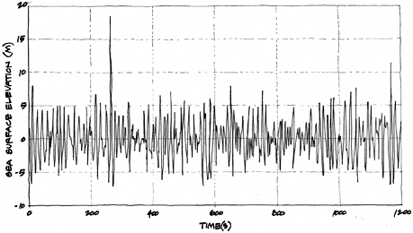
FIGURE 18 Draupner oil platform wave height, January 1, 1995.
fleet of small Japanese fishing boats. The radio waves were suddenly filled with Mayday calls. Barker and his crewmates rescued the crew of one boat, losing a lifeboat to a rogue wave in the process. That was the first time he’d heard the term used. It stuck with him.
He bought Nepenthe in 1979 and began outfitting her for cruising, sailing days and weekends in Southern California whenever he had a chance. In Chapter 2, I mentioned sailing to Santa Barbara Island in my first boat; subsequently, I’ve been there in Dreams perhaps a dozen times.
Barker told me that he’d been to Santa Barbara Island also; what impressed me was that his trip to this island was the longest ocean passage he’d made on a sailboat before setting off for Australia! He left California on October 14, 1982, and made his first landfall as planned at Pago Pago, American Samoa, 54 days later. It was a little longer than going to Santa Barbara Island.
After successfully reaching Australia, Barker was single-handing Nepenthe between Bundaberg, Australia, and Noumea, New Caledonia, somewhere around the Tropic of Capricorn and longitude 160 degrees east, in the Tasman Sea. In his own words, here’s his story.
“I was beating on a starboard tack with a storm jib and fully reefed
mainsail. Winds were 40 knots, gusting to 60; but all seemed well. I was sitting in the cockpit, dead tired, approaching the end of a second day without sleep, when a wall of water dropped into the cockpit. It flattened out around my ankles on the cockpit floor, about 8 inches deep. That brought me to full alert. I scrambled to slide a second board in the companionway doorway. Before I could get the next board in place, a second mountain of water washed in from the port stern quarter. This time it washed over the companionway board and down into the cabin. I quickly got the second and a third board in place and then grabbed a five-gallon bucket and started bailing out the knee-deep cockpit. Once I had it under control, I put one leg over the companionway boards and reached below for a towel to stuff into the door boards to make them a little more water-tight. At that precise moment, the third wave hit starboard with such force that I was thrown in a heap onto the cabin floor. I staggered to my feet, my left arm numb and useless for several days, but fortunately not broken.
“This was my introduction to rogue waves. It wasn’t an introductory course, with a single wave; I had a graduate course, with the full Three Sisters’ treatment.”24
Barker survived the waves this time, and several more times as well, and brought Nepenthe safely back to California. He wrote a journal of his trip, fittingly titled Rogue Wave, from which this excerpt is taken. At several points in his journal, Barker sums it up by saying, “The devil lives in the Tasman Sea, and he’ll beat you to death with his rogue waves if you don’t watch out for him….”
You can meet Barker if you care to travel to San Pedro (the Port of Los Angeles) and board the SS Lane Victory. The Lane Victory, now a national monument, is where Barker works as a volunteer steam engineer. The Lane Victory is a fully restored, 455-foot-long World War II victory ship that sails from San Pedro on Saturdays and Sundays during the summer. Enjoy a cruise to Catalina, along with a simulated air attack by a squadron of World War II planes that come screaming out of the sky! Not only can you meet Barker, you can support this historic merchant marine steamship—a worthy cause.
In the 20-year period from 1980 to 2000, more than 200 supercarriers—bulk carriers, combination carriers, and crude oil tankers
more than 656 feet (200 meters) long—were lost to storms.25 In a number of cases, the cause was a giant wave that hit the vessel suddenly without warning. Sometimes these waves appeared in the midst of a storm; on other occasions they occurred when seas were moderate. It is not just bulk carriers and tankers that have been hit. The preceding paragraphs include only a small sample of known incidents. Virtually all types of vessels—oil tankers, bulk carriers, container ships, passenger liners and cruise ships, fishing boats, even aircraft carriers and naval ships designed to withstand bomb blasts—have fallen victim to extreme waves at some time or another. (As part of my research I compiled a listing of more than 70 such incidents.)
HOW HIGH CAN THEY GET?
In addition to the wave heights seen by shipboard observers or personnel on offshore oil platforms, wave heights have been measured and recorded for a period of years at various locations by instruments. By examining large numbers of records that cover a long period of time, it is possible to determine, on average, how frequently a wave of a certain height can be expected to occur. In technical jargon, this is referred to as the return period (measured as 2, 5, 10, 50, or 100 years), meaning that on average a wave of that particular size can be expected once every 2, 5, 10, or so many years.
Wave measurements have been made by weather ships, nine of which are located in the North Atlantic along the routes most frequently traveled by merchant shipping between Europe and North America. In the Atlantic, the highest significant wave height expected to occur once in 2 years, ranged from 23 to 39 feet; once in 50 years, it could be as high as 43 to 75 feet. In the Pacific, the range for once in 2 years was 20 to 36 feet, and for once in 50 years, 36 to 66 feet.
These are the values for the significant wave height. However, remember that the significant wave height is the average of the top one-third of the highest waves. It is not the extreme wave. In the Atlantic, a probability analysis would show that the extreme wave could be as much as 131 feet and in the Pacific as much as 118 feet.26 In the North Sea, predictions of maximum wave height give 111 feet. The highest
measured to date is the famous 84-foot “New Year’s” wave of January 1, 1995, recorded at the Draupner oil platform.
At one time, measurements of wave heights in the North Atlantic showed that average wave heights seemed to be increasing, a pattern also observed in the last 15 years. Today this is a matter of scientific debate. Is this a trend, or does it just reflect the natural long-term variation of weather patterns? Weather seems to be moving north, bringing more intense storms to the north. This could be due to migration of warmer water north (known to advance and retreat periodically), to expansion or shrinkage of the ice boundary, or to storm patterns that “huddle” ice packs together.
Surprisingly, 100-foot-high waves have recently been measured off the west coast of Canada. Commencing just south of Vancouver Island and continuing north to the British Columbia–Alaska border, the Canadian government had 16 weather buoys. Some were placed between Vancouver Island and the mainland, others in Hecate Strait, and a number offshore on the west side of Vancouver and Queen Charlotte islands. During a storm on December 10, 1993, the East Dellwood buoy, located 61 nautical miles west of Cape Scott, recorded an extreme wave of 101 feet. The wave occurred at a time when the buoy recorded significant wave heights of 40 feet. Earlier, on December 20, 1991, the south Hecate buoy measured a wave that was 100 feet high. On December 13, 1992, the West Dixon entrance buoy was swamped by an 85-foot-high wave. It seems as though the waters around Vancouver and Queen Charlotte islands would be a good place to avoid during the month of December.27
One of the earliest reliable measurements of a giant wave was made on February 7, 1933, by the U.S. Navy oil tanker Ramapo while steaming in the North Pacific. The USS Ramapo (AO-12) was a fleet oil tanker capable of carrying 70,000 barrels of fuel oil to refuel navy ships at sea. The vessel was launched in 1919 and initially saw service in the Caribbean, carrying fuel from Texas to Guantanamo Bay, Cuba. In the 1920s, she was transferred to the Pacific, where she serviced ships of the Asiatic Fleet, carrying oil from San Pedro, California, to the Philippines and China. Ramapo was in Pearl Harbor when the Japanese attacked, returned fire, may have shot down one plane, and miraculously
sustained no damage. Later in the war, during a bad storm near the Aleutian Islands in December 1942, the Ramapo was credited with rescuing the entire crew of the USS Wasmuth, a minesweeper that sank when depth charges broke loose on deck during heavy weather and exploded. However, the Ramapo is best known for providing the first carefully documented record of an extreme wave.28
In February 1933, while on its usual run from Manila back to California, Ramapo was caught up in a ferocious seven-day storm. Winds blew at speeds of 60 knots and higher. An officer on watch on the bridge observed a wave approaching the stern of the vessel at a height just above the crow’s nest on the main mast, while the stern of the vessel was sunk in the trough of the wave. When the geometry of this sighting was worked out using the known height of the mast and the length of the vessel, the wave was found to be 112 feet high (see Figure 19). The period of the wave was measured as 14.8 seconds and its wavelength calculated to be 1,100 feet. Since the Ramapo was only 480 feet long, she was able to ride through the wave without having her back broken while suspended on a crest or having her stern buried under tons of water.29
THE MAXWAVE PROJECT
The Commission of the European Communities recently initiated a multination research project on extreme waves.30 The MaxWave project goals are to develop a better understanding of extreme waves, determine their frequency of occurrence and the places where they are most likely to occur, and develop methods of predicting their occurrence. The project addresses extreme wave occurrence not only in oceans and the effects on shipping, but also in shallow and coastal waters and the effects on offshore oil platforms and ports and harbors.
MaxWave is divided into 10 tasks, commencing with the establishment of a database by investigating known extreme wave incidents and developing extreme wave statistics (wave heights, periods, frequency of occurrence) from buoy and satellite radar data from which it will analyze the regional distribution of extreme waves. Known ship accidents involving extreme waves also will be analyzed and, where pos-

FIGURE 19 USS Ramapo wave height measurement scheme.
sible, compared to hindcasts of existing sea conditions at the time of the incident. By using the results obtained from the research, wave conditions and criteria for designing safer ships and offshore structures will be developed. The research is ongoing, but one early finding is that waves 66 to 98 feet high occur much more frequently than previously thought.
As part of the MaxWave team, Dr. Susanne Lehner and her colleagues used satellites and radar imaging to scan large areas of the oceans, looking for rogue waves. In 2001, they discovered 10 waves exceeding 80 feet in height. Due to limitations on the data sets and sampling frequency, this number probably underestimates the actual number occurring. Fortunately, many of these waves are short-lived—they are born suddenly, rise up, and collapse quickly without propagating for any significant distance. Unless a ship is in the vicinity, or a satellite overhead, they live and die in obscurity, somewhere in the vastness of the world’s oceans.
Another extreme wave measurement is that described in Chapter 4, when Hurricane Ivan passed over an array of underwater sensors that detected a 91-foot-high wave.
BOTTOM LINE
In conclusion, there is ample evidence for the occurrence of extreme waves. As the examples listed above demonstrate, big waves can
no longer be explained away as simply a sailor’s exaggeration. (See Table 5).
After hearing or reading dozens of accounts of extreme wave incidents, I was impressed with the consistency of the descriptions. Inevitably, they all contain several of these phrases: “It came out of nowhere; it was a wall of water; it towered over the boat; it was as if we’d fallen into a hole in the sea.”
Frightening images—but what do they portend for the future? Is it safe to say that modern ships are sufficiently robust to survive the worst weather that oceans can throw at them? Would you or I want to be on a vessel facing the Draupner wave?
TABLE 5 The Evidence for Extreme Waves
|
Description and Location (year) |
Wave Height in Feet |
||
|
Significant |
Extreme |
Notesa |
|
|
Lituya Bay, Alaska (1958) |
320 |
1,700 |
Landslide |
|
Sydney-Hobart Race (1998) |
40-60 |
140 |
Measured |
|
Krakatoa, Indonesia |
— |
133 |
Volcano |
|
Weather ship data (ca. 1980) |
|
|
|
|
Atlantic |
43-75 |
131 |
Calculated |
|
Pacific |
36-66 |
118 |
Calculated |
|
Offshore platforms |
|
|
|
|
North Sea |
— |
111 |
Calculated |
|
USS Ramapo, N. Pacific (1933) |
— |
112 |
Measured |
|
East Dellwood, N. Pacific (1993) |
40 |
101 |
Measured |
|
Ocean Ranger, N. Atlantic (1982) |
— |
100 |
Estimated |
|
SS Bremen, S. Atlantic (2001) |
— |
98 |
Estimated |
|
Submarine Grouper, Atlantic |
Calm seas |
98 |
Measured |
|
Caledonian Star, S. Atlantic (2001) |
— |
98 |
Estimated |
|
Athene, Indian Ocean (1977) |
— |
98 |
Estimated |
|
Queen Elizabeth 2, N. Atlantic |
— |
95 |
Estimated |
|
Hurricane Ivan, Atlantic (2004) |
— |
91 |
Measured |
|
Queen Elizabeth, N. Atlantic (1943) |
— |
90 |
Estimated |
|
Unnamed vessel, Atlantic (1960s) |
— |
85 |
Estimated |
|
Draupner platform, N. Sea (1995) |
39 |
84 |
Measured |
|
Esso Nederland, Agulhas current |
— |
82 |
Estimated |
|
MaxWave satellite study (2001) |
— |
80+ |
Measured |
|
May 22 Chile earthquake (1960) |
— |
82 |
Runup |
|
Ob, Southern Ocean (1955-1956) |
— |
82 |
Estimated |
|
Michelangelo, N. Atlantic (1966) |
20-30 |
81 |
Estimated |
|
USS Milwaukee, N. Atlantic (1975) |
— |
75 |
Estimated |
|
Tanker Atigun Pass, Pacific (1982) |
— |
70 |
Estimated |
|
USS Wateree, Chile (1868) |
— |
69 |
Tsunami |
|
Schiehallion, N. Atlantic (1998) |
46 |
66+ |
Measured |
|
Munchen, N. Atlantic (1978) |
— |
66+ |
Estimated |
|
MV Explorer, N. Pacific (2004) |
— |
61 |
Estimated |
|
Independence, N. Atlantic (1977) |
25-30 |
55-60 |
Estimated |
|
Teal Arrow, N. Atlantic (1995) |
— |
50 |
Hurricane |
|
Texas Tower 4, N. Atlantic (1960) |
— |
50 |
Hurricane |
|
Polar Star, N. Pacific (1985) |
11.5 |
35 |
Storm |
|
March 27 Alaska earthquake (1964) |
— |
33 |
Tsunami |
|
aIn compiling this table, in many cases where height is “estimated,” the estimate is based on the height above the waterline where significant damage was observed. The likelihood is that this underestimates the wave height. N means north; S means south. |
|||