Tools and Technology for Roadside Vegetation Asset Management: A Guide (2025)
Chapter: Appendix A: Taxonomy and Definitions of Roadside Vegetation Assets

APPENDIX A
Taxonomy and Definitions of Roadside Vegetation Assets
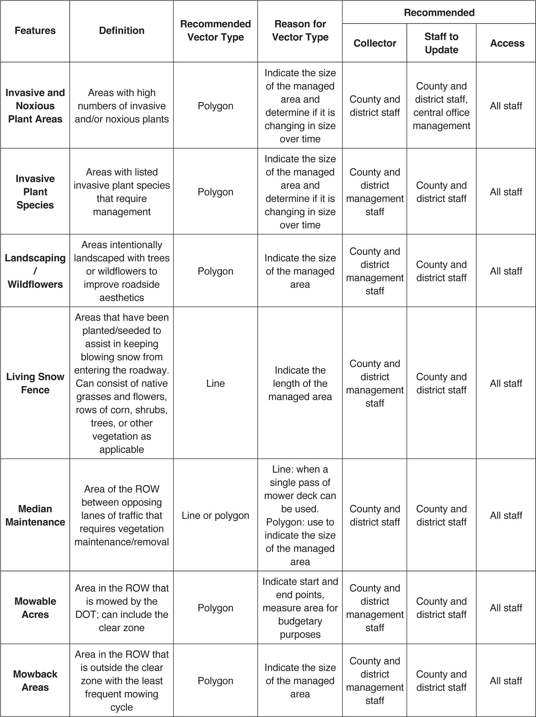
Table A-1. Vegetation data dictionary.

(continued on next page)
Long Description.
The column headers of the table are Features, Definition, and Recommended Vector Type, Reason for Vector Type, Recommended: Collector, Staff to Update, and Access. The fifth column has sub-columns. The data given in the table row-wise are as follows: Row 1: PGR and Herbicide Areas are defined as areas treated with plant growth regulator or herbicide. A polygon is the recommended vector type because this can indicate the size of the managed area and determine if it is changing in size over time. Ideally, data collectors include county and district management staff; county, district, and central office staff can update the records; and all staff have access to the records. Row 2: Bare Ground Management Areas are defined as areas where the goal is a lack of vegetation. A line or polygon is the recommended vector type to indicate the size or length of the managed area and if the size is changing over time. Ideally, data collectors include county and district management staff; county, district, and central office staff can update the records; and all staff have access to the records. Row 3: The Clear Zone is defined as areas adjacent to the road edge. A line or polygon is the recommended vector type to indicate start and end points. Ideally, county and district management staff collect and update records and all staff have access to the records. Row 4: Formalized Landscape Planting is defined as intentionally planted areas with regularly scheduled maintenance. A polygon is the recommended vector type to indicate the size of the managed area. Ideally, data collectors include county and district management staff; county, district, and central office staff can update the records, and all staff have access to the records. Row 5: Hazard trees are defined as individual trees requiring maintenance or removal to ensure motorist safety. The recommended vector type is a point to indicate the number and locations of all affected trees. Ideally, data collectors include county and district management staff, county and district staff can update the records, and all staff have access to the records. Row 6: Intersection mowing is defined as grassy areas of the right-of-way where sight distance is critical. A line or a polygon is the recommended vector type to indicate start and end points as the asset is not uniform in dimension. Ideally, county and district management staff collect and update records and all staff have access to the records.
Table A-1. (Continued).
Long Description.
Row 7: Invasive and Noxious Plant Areas are defined as areas with high numbers of invasive and/or noxious plants. A polygon is the recommended vector type to indicate the size of the managed area and determine if the size is changing in size over time. Ideally, data collectors include county and district staff, county and district staff along with central office management can update the records, and all staff have access to the records. Row 8: Invasive Plant Areas are defined as areas with listed invasive plant species requiring management. A polygon is the recommended vector type to indicate the size of the managed area and determine if the size is changing in size over time. Ideally, data collectors include county and district management staff, county and district staff can update the records, and all staff have access to the records. Row 9: Landscaping/Wildflowers are defined as areas intentionally landscaped with trees or wildflowers to improve roadside aesthetics. A polygon is the recommended vector type to indicate the size of the managed area. Ideally, data collectors include county and district management staff, county and district staff can update the records, and all staff have access to the records. Row 10: Living Snow Fences are defined as areas that have been planted or seeded to assist in keeping blowing snow from entering the roadway. These areas can consist of native grasses and flowers and rows of corn, shrubs, trees, or other vegetation as applicable. A line is the recommended vector type to indicate the length of the managed area. Ideally, data collectors include county and district management staff, county and district staff can update the records, and all staff have access to the records. Row 11: Median Maintenance is defined as the area of the right-of-way between opposing lanes of traffic that requires vegetation maintenance or vegetation removal. A line is the recommended vector type when a single pass of mower deck is to be used, or a polygon is recommended to indicate the size of the managed area. Ideally, county and district management staff collect and update records and all staff have access to the records. Row 12: Mowable Acres are defined as areas in the right-of-way that are mowed, including the clear zone. A polygon is the recommended vector type to indicate start and end points and measure the area for budgetary purposes. Ideally, data collectors include county and district management staff, county and district staff can update the records, and all staff have access to the records. Row 13: Mowback Areas are defined as the area in the right-of-way that is outside of the clear zone with the least-frequent mowing. A polygon is the recommended vector type to indicate the size of the managed area. Ideally, data collectors include county and district management staff, county and district staff can update the records, and all staff have access to the records.

(continued on next page)
Long Description.
Row 14: Native grasses and forbs are defined as areas intentionally planted with native grasses and forbs or areas managed to return to native grasses and forbs. A polygon is the recommended vector type because it indicates the size of the managed area. Ideally, data collectors include county and district management staff, county and district staff can update the records, and all staff have access to the records. Row 15: Naturalized Areas are defined as areas outside the clear zone with the least-frequent mowing cycles. Management of these areas will be designed to remove undesired plants, such as hazard trees and invasive plant species. A line, point, or polygon is the recommended vector type to indicate the size and location of the managed area. The width and length of the naturalized areas should indicate the mapping vector type. Ideally, data collectors include county and district management staff, county and district staff can update the records, and all staff have access to the records. Row 16: No-Mow Areas are defined as areas in the right-of-way that are excluded from mowing. A polygon is the recommended vector type to indicate the size of the managed area. Ideally, data collectors include county and district management staff, county and district staff can update the records, and all staff have access to the records. Row 17: No-Spray Areas are defined as areas in the right-of-way that are excluded from herbicide applications. A polygon is the recommended vector type to indicate the size of the managed area. Ideally, data collectors include county and district management staff; county and district staff can update the records; and all staff have access to the records. Row 18: Planned Treatment Point is defined as an area with vegetation management needs. A polygon is the recommended vector type to indicate the size of the managed area and determine if the area is changing in size over time. Ideally, data collectors include county and district management staff, county and district staff can update the records, and all staff have access to the records. Row 19: Priority Noxious Weed areas are defined as areas with listed noxious plant species that require management. A polygon is the recommended vector type to indicate the size of the managed area and to determine if the area is changing in size over time. Ideally, data collectors include county and district management staff, county and district staff can update the records, and all staff have access to the records. Row 20: Rest Stop Plantings are defined as areas intentionally planted with native or nonnative forbs or grasses at and around rest stops. A polygon is the recommended vector type to indicate the size of the managed area. Ideally, data collectors include county and district management staff, county and district staff can update the records, and all staff have access to the records.

Long Description.
Row 21: Species of Concern are defined as individual plants or groupings of plants at risk of becoming listed by state and/or federal agencies as endangered or threatened due to restricted distribution, specialized habitat needs, or other factors. The recommended vector types are a point for specific plants and a polygon for larger groupings of plants. Ideally, data collectors include environmental division staff; county, district, and central office staff can update the records, and all staff have access to the records. Row 22: Threatened and Endangered Species are defined as individual plants or groupings of plants listed as threatened or endangered. A point or a polygon is the recommended vector type to indicate the size of the managed area. Ideally, data collectors include environmental division staff; county, district, and central office staff can update the records, and all staff have access to the records. Row 23: Tree is defined as individual trees that may need trimming or removal. A point is the recommended vector type to indicate the number and locations of trees. Ideally, county and district management staff collect and update records and all staff have access to the records. Row 24: Tree Grove is defined as a stand of trees that may need trimming or removal. A point is the recommended vector type if a DOT is concerned with locations of tree stands but does not need to know their size; a polygon is recommended in tree-dense areas where significant work is required. Ideally, county and district management staff collect and update records and all staff have access to the records. Row 25: A Vehicle Firebreak Pull Off is defined as bare ground along the right-of-way adjacent to the road edge that is used to reduce the risk of fires started by motor vehicles. A line or polygon is the recommended vector type to indicate the size of the managed area. Ideally, data collectors include county and district management staff, county and district staff can update the records, and all staff have access to the records. Row 26: Wildflowers are defined as areas intentionally landscaped with wildflowers to improve roadside aesthetics. A polygon is the recommended vector type to indicate the size of the managed area. Ideally, data collectors include county and district management staff, county and district staff can update the records, and all staff have access to the records.
(continued on next page)
Long Description.
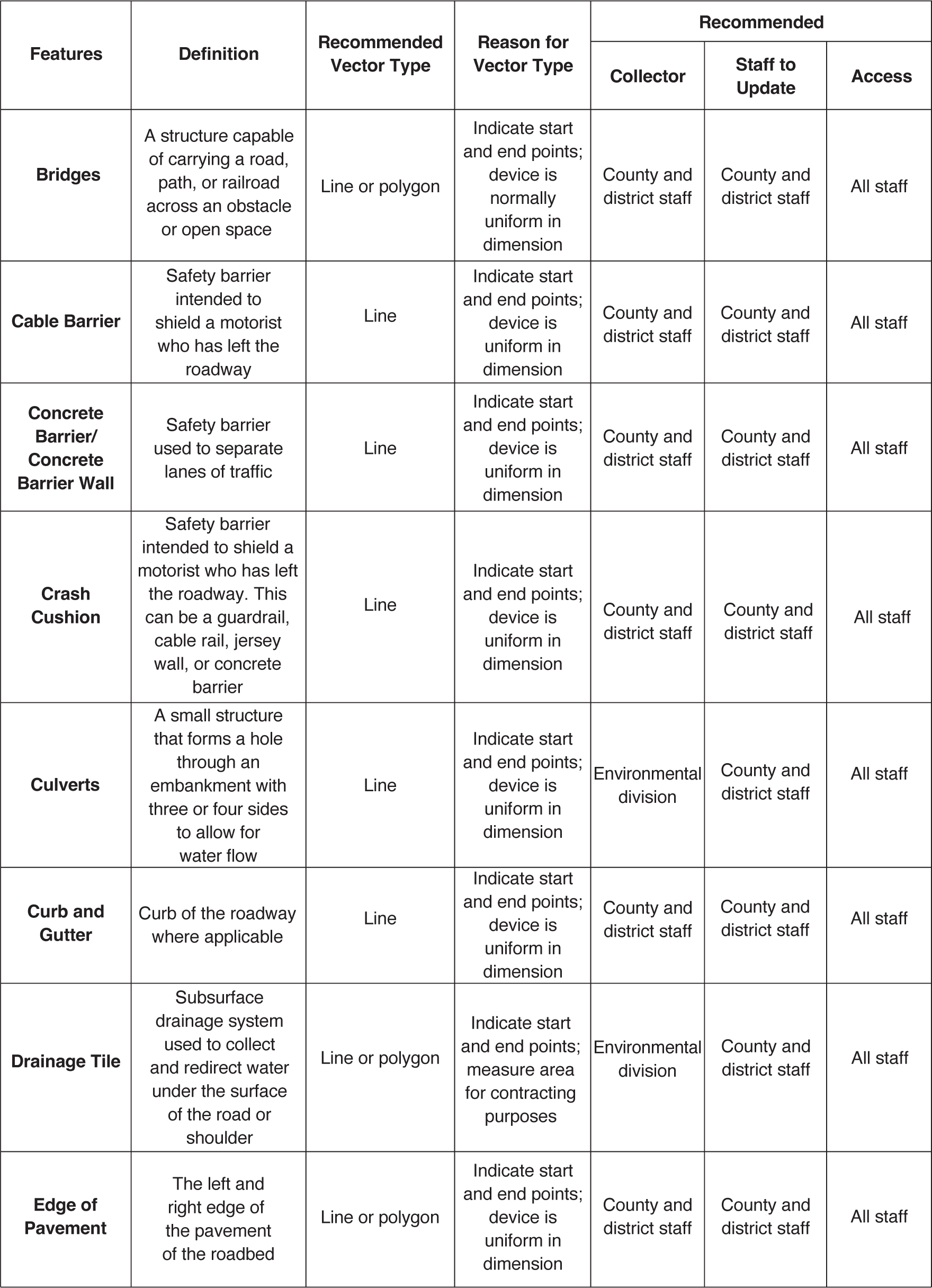
The column headers of the table are Features, Definition, and Recommended Vector Type, Reason for Vector Type, Recommended: Collector, Staff to Update, and Access. The data given in the table row-wise are as follows: Row 1: Bridges are defined as a structure that can carry a road, path, or railroad across an obstacle or open space. A line or polygon is the recommended vector type to indicate the starting and ending points. The device is normally uniform in dimension. Ideally, county and district management staff collect and update records and all staff have access to the records. Row 2: Cable Barrier is defined as a safety barrier intended to shield a motorist who has left the roadway. A line is the recommended vector type to indicate the starting and ending points. The device is uniform in dimension. Ideally, county and district management staff collect and update records and all staff have access to the records. Row 3: Concrete Barrier or Concrete Barrier Wall is a safety barrier used to separate lanes of traffic. A line is the recommended vector type to indicate the starting and ending points. The device is uniform in dimension. Ideally, county and district management staff collect and update records and all staff have access to the records. Row 4: Crash Cushion, a safety barrier such as a guardrail, cable rail, jersey wall, or concrete barrier, is intended to shield a motorist who has left the roadway. A line is the recommended vector type to indicate the starting and ending points. The device is uniform in dimension. Ideally, county and district management staff collect and update records and all staff have access to the records. Row 5: Culverts are defined as small structures that form a hole through an embankment with three or four sides to allow for water flow. A line is the recommended vector type to indicate the starting and ending points. The device is uniform in dimension. Ideally, data collectors include environmental division staff; county and district staff can update the records; and all staff have access to the records. Row 6: Curb and Gutters are defined as the curb of the roadway, where applicable. A line is the recommended vector type to indicate the starting and ending points. The device is uniform in dimension. Ideally, county and district management staff collect and update records and all staff have access to the records. Row 7: Drainage Tile is defined as a subsurface drainage system used to collect and redirect water under the surface of the road or shoulder. These areas must be checked to ensure water flow is occurring correctly. A line or polygon is the recommended vector type to indicate the starting and ending points and to measure the area for contracting purposes. Ideally, data collectors include environmental division staff; county and district staff can update the records, and all staff have access to the records. Row 8: The Edge of Pavement is defined as the left and right edges of the pavement of the road. A line or polygon is the recommended vector type to indicate the starting and ending points. The device is uniform in dimension. Ideally, county and district management staff collect and update records and all staff have access to the records.
Long Description.
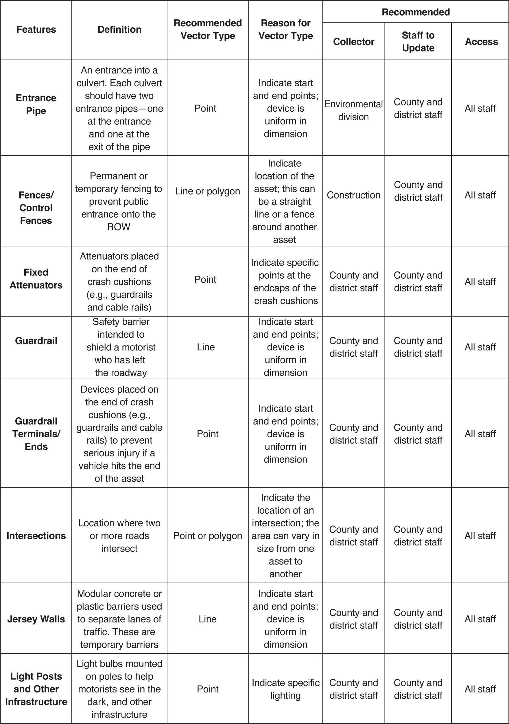
Row 9: Entrance Pipe is defined as an entrance into a culvert. Each culvert should have two entrance pipes—one at the entrance and one at the exit of the pipe. A point is the recommended vector type to indicate the starting and ending points. Ideally, data collectors include environmental division staff; county and district staff can update the records, and all staff have access to the records. Row 10: Fences or Control Fences is defined as a permanent or temporary fencing to prevent public entrance onto the right-of-way. A line or polygon is the recommended vector type to indicate the starting and ending points. The device is uniform in dimension. Ideally, data collectors include construction staff; county and district staff can update the records; and all staff have access to the records. Row 11: Fixed Attenuators are defined as attenuators placed on the ends of crash cushions, such as guardrails and cable rails. A point is the recommended vector type to indicate specific points at the endcaps of the crash cushions. The device is uniform in dimension. Ideally, county and district management staff collect and update records and all staff have access to the records. Row 12: A Guardrail is defined as a safety barrier intended to shield a motorist who has left the roadway. A line is the recommended vector type to indicate the starting and ending points. The device is uniform in dimension. Ideally, county and district management staff collect and update records and all staff have access to the records. Row 13: Guardrail Terminals or Ends are defined as devices placed on the end of crash cushions, such as guardrails and cable rails, that are meant to prevent serious injury upon a vehicle hitting the end of the asset. A point is the recommended vector type to indicate the starting and ending points. The device is uniform in dimension. Ideally, county and district management staff collect and update records and all staff have access to the records. Row 14: Intersections are defined as a location where two or more roads intersect. A point or polygon is the recommended vector type to indicate the location of an intersection. The area can vary in size from one asset to another. Ideally, county and district management staff collect and update records and all staff have access to the records. Row 15: Jersey Walls are defined as temporary modular concrete or plastic barriers used to separate lanes of traffic. A line is the recommended vector type to indicate the starting and ending points. The device is uniform in dimension. Ideally, county and district management staff collect and update records and all staff have access to the records. Row 16: Light Posts and Other Infrastructure are defined as light bulbs mounted on poles to help motorists see in the dark, and other infrastructure. A point is the recommended vector type to indicate specific lighting. Ideally, county and district management staff collect and update records and all staff have access to the records.

(continued on next page)
Long Description.
Row 17: A Median is defined as a painted or physical feature designed to separate lanes or directions of travel. A line or point is the recommended vector type to indicate the starting and ending points. The device is not uniform in dimension. Ideally, county and district management staff collect and update records and all staff have access to the records. Row 18: Mile Marker Signs are defined as signs with numeric values along the roadway to enable location identification. A point is the recommended vector point to indicate specific sign locations. Ideally, county and district management staff collect and update records and all staff have access to the records. Row 19: Post Matting is defined as a vegetative barrier installed under cables and guardrails. A line is the recommended vector type to indicate the starting and ending points. The device is uniform in dimension. Ideally, county and district management staff collect and update records and all staff have access to the records. Row 20: A Retaining Wall is defined as a permanent wall designed to retain soil and rocks to prevent landslides. A line or polygon is the recommended vector type to indicate the starting and ending points. The device is uniform in dimension. Ideally, data collectors include construction staff; county and district staff can update the records, and all staff have access to the records. Row 21: A Shoulder is defined as a paved area along the sides of the roadway intended to allow space for a vehicle to pull over. A line or polygon is the recommended vector type to indicate the starting and ending points. The device is usually uniform in dimension. Ideally, county and district management staff collect and update records and all staff have access to the records. Row 22: Sign Posts are defined as permanent posts for ground-driven information boards for the traveling public. A point is the recommended vector type to indicate specific sign locations. Ideally, county and district management staff collect and update records and all staff have access to the records. Row 23: Signs are defined as permanent, ground-driven information boards for the traveling public. A point is the recommended vector type to indicate specific sign locations. Ideally, county and district management staff collect and update records and all staff have access to the records. Row 24: Sound Walls or Noise Walls, typically installed when noise from the highway can cause severe disruption to local residents, are designed to absorb sound. A line is the recommended vector type to indicate the starting and ending points. The device is uniform in dimension. Ideally, county and district management staff collect and update records and all staff have access to the records. Row 25: Stormwater Ditch or Ditches, an area of the right-of-way where drainage is critical, must be checked to ensure water flow is occurring correctly. A line or polygon is the recommended vector type to indicate the starting and ending points. The device is usually uniform in dimension. Ideally, data collectors include environmental division staff; county and district staff can update the records; and all staff have access to the records.
Long Description.
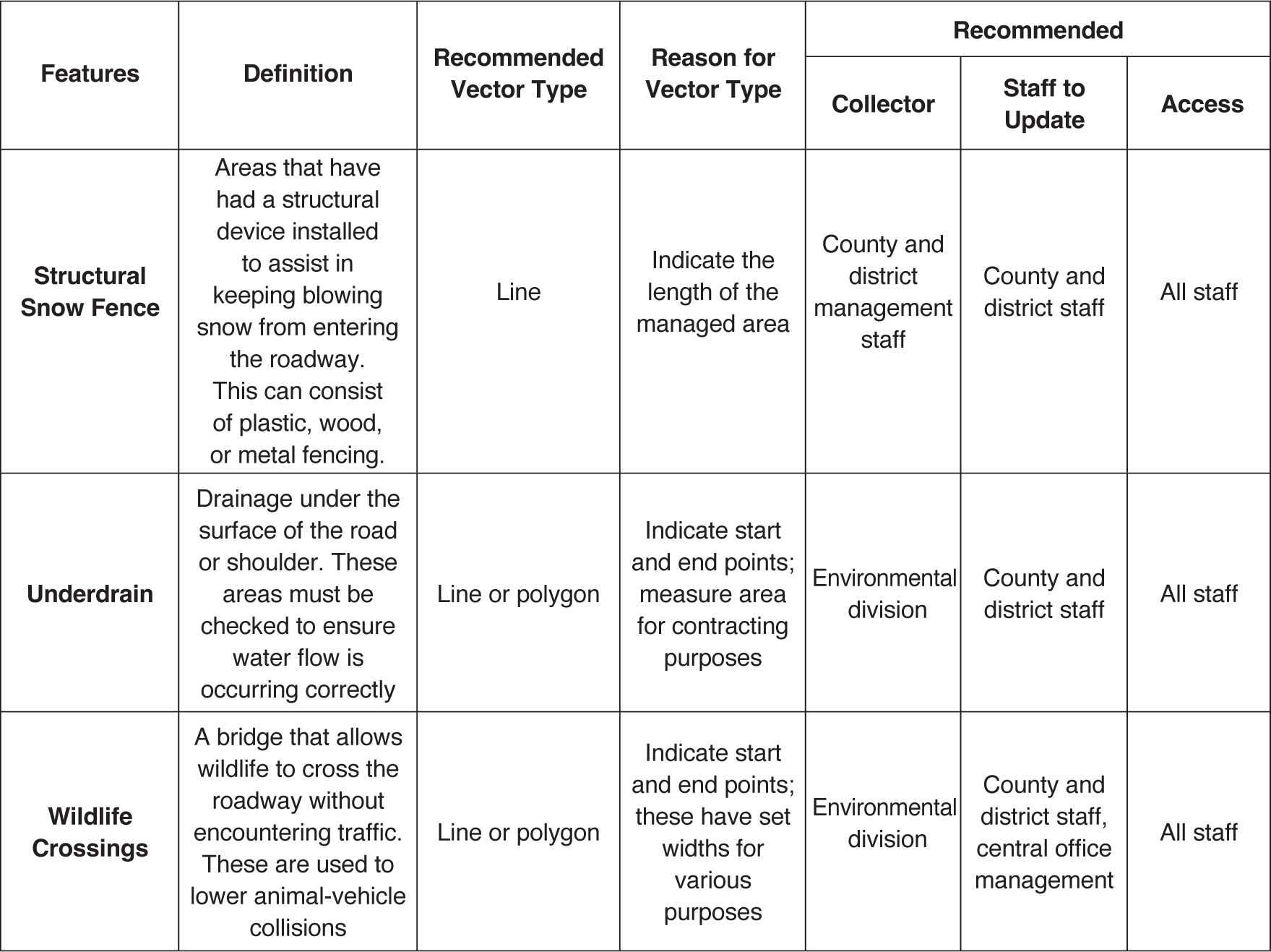
Row 26: Structural Snow Fences are defined as areas that have had a structural device installed to assist in keeping blowing snow from entering the roadway. Such devices can consist of plastic, wood, or metal fencing. A line is the recommended vector type to indicate the length of the managed area. Row 27: An Underdrain, a device that provides drainage under the surface of the road or shoulder, must be checked to ensure water flow is occurring correctly. A line or polygon is the recommended vector type to indicate the starting and ending points and to measure the area for contracting purposes. Ideally, data collectors include environmental division staff; county and district staff can update the records; and all staff have access to the records. Row 28: Wildlife Crossings are defined as bridges that allow wildlife to cross the roadway without coming into contact with traffic to lower the number of animal-vehicle collisions. A line or polygon is the recommended vector type to indicate the starting and ending points. Wildlife crossings have set widths for various purposes. Ideally, data collectors include environmental division staff; county, district, and central office management staff can update the records, and all staff have access to the records.


