Census Data Field Guide for Transportation Applications (2025)
Chapter: 3 AASHTO Census Transportation Solutions

CHAPTER 3
AASHTO Census Transportation Solutions
The ACTS program, formerly known as the CTPP program, is an AASHTO-sponsored Technical Services Program funded by member state transportation agencies and operates with support from the FHWA, Office of the Secretary for Research and Technology, FTA, the Census Bureau, MPOs, and TRB. The ACTS program includes data products (referred to as CTPP), training and technical assistance, and research and outreach. The program is designed for the transportation community by the transportation community and is guided by an oversight board composed of MPOs and department of transportation (DOT) representatives from across the United States. ACTS uses data from the ACS and releases products based on the 5-year ACS to produce the CTPP data. The CTPP summarizes data by place of residence, place of work, and flows from home to work. The data are available in both census geography and custom geographies such as TAZs and traffic analysis districts (TADs) and are available for unique universes such as workers in households. The CTPP data are built as a special tabulation by the Census Bureau for the transportation community.
3.1 History of the CTPP Program
The 1970 census provided block-level data on commuting origins and destinations, which enabled the development of the Urban Transportation Planning Package (UTPP) (National Research Council 1995). As described in Modernizing the U.S. Census (National Research Council 1995), the UTPP was a special tabulation of census data tailored to the geographic areas used in transportation planning for individual metropolitan areas. Local transportation planning organizations defined the blocks that constituted their TAZs, and the Census Bureau produced a standard set of tabulations for those zones on a cost-reimbursable basis. The FHWA provided the specifications for the content of the UTPP to the Census Bureau. Approximately 120 UTPPs were prepared using the 1970 census data.
In 1980, the Census Bureau again produced the UTPP. However, in this release of the UTPP, specifications were developed and submitted to the Census Bureau by an ad hoc TRB committee of transportation planners with funding for development and administration of the 1980 project provided by the U.S. DOT. The number of packages produced increased to more than 150.
The UTPP evolved into the CTPP following the 1990 census. As part of the 1990 CTPP, two transportation planning packages were produced by the Census Bureau: (1) statewide packages for each state and the District of Columbia and (2) urban packages for the transportation study area defined by each MPO. Funding for the development and administration of the 1990 CTPP was sponsored by the state DOTs under a pooled funding arrangement with AASHTO that supported the production of data for the entire country instead of only those areas that had purchased the data, as had been the case with previous censuses. The number of state and metropolitan packages produced increased to 415 for the 1990 census.
The 1990 CTPP followed the same general format as the programs established in 1970 and 1980. An ad hoc working group, consisting of members from AASHTO, the National Association of Regional Councils, FHWA, FTA, the Census Bureau, and experts from states and MPOs, developed the specifications for both the metropolitan and statewide datasets in the 1990 CTPP.
The statewide tabulations were the first product of the 1990 CTPP, with a file produced for each state containing data on households, persons, and workers living in each city and county; all workers working in each city and county; and commuter flows between counties and cities. The urban tabulations, delivered after the statewide packages, were similar to the statewide data but tabulated based on census tracts or TAZs. An urban package was produced for each metropolitan area for which the Census Bureau had an address coding capability.
In a key publication that focused on 50 years of using census data for transportation planning purposes, Salopek (2018) discusses the transportation planning packages of 1980, 1990, and 2000 and the main issues that the Census Bureau was trying to address. The 2000 CTPP program focused on improving data accessibility for a wide range of participants and leveraging more modern data processing and analysis technologies. As described by Salopek (2018), the programʼs first step was to contract with two companies to create software for distributing the 2000 CTPP data on CD. Procedures were provided to agencies to standardize the creation of their TAZ equivalency files and for examining and updating the workplace files (major employer lists) used in place-of-work coding.
FHWA and the Census Bureauʼs geography division sponsored an ArcView application called TAZ-UP, which used TIGER-Line files to help CTPP 2000 customers define TAZs. The Journey-to-Work Branch also contracted with ESRI to develop the Workplace Update Extension (Work-UP), an ArcView application that allowed MPOs to verify, correct, and add entries for employers in their area, ensuring more accurate and complete workplace data. Since the Census Bureau does not collect workplace geographic information below the place level, it developed an extended place-of-work allocation system in the 2000 census, going beyond the main censusʼs allocation methods. This resulted in a greater number of records containing codes down to the block level.
DRB Charter
- Establish and review the Census Bureauʼs disclosure-limitation policy regarding all publicly available data products.
- Review and approve proposed disclosure-limitation procedures for the release of all publicly available data products.
- Communicate the disclosure-limitation policy to program managers, Census Bureau officials, data users, and prospective sponsors.
- Initiate and coordinate research on the disclosure potential in microdata and tabular data and the effectiveness of disclosure-limitation techniques.
- Revise the Census Bureauʼs disclosure-limitation policy as necessary.
3.2 The Disclosure Review Board
Following the transition to the ACS, a series of changes impacted the CTPP due to the smaller sample size in the ACS compared to the sample size in the long form that was prevalent until 2000. In 2008, the Census Bureau Disclosure Review Board (DRB) reviewed the first ACS-based CTPP product that was limited to the 3-year ACS data. The DRB handed down the following ruling (“The CTPP and Disclosure: A Resource Paper, or Why Collect Data and Throw it Away?” 2008):
The data will be rounded as all ACS special tabulations. DRB rules for means, medians and other quantiles will be applied. For all tables where means of transportation is shown but not crossed with any other variable, there is no threshold on the means of transportation categories. For all tables where means of transportation is shown and crossed with one or more other variables, there must be at least 3 unweighted cases for each category of means of transportation in a given geographic area to be shown. Categories and/or geographic areas should be collapsed to meet this threshold. For all flow tables, there must be at least 3 unweighted cases per pair of geographic areas with the exception of Total Workers univariate and Means of Transportation univariate (no required threshold).
This ruling by the DRB led to the AASHTO Standing Committee on Planning (SCOP) approving funding for NCHRP Project 08-79, “Producing Transportation Data Products from the American Community Survey that Comply with Disclosure Rules,” which was published as
NCHRP Web-Only Document 180 (Krenzke et al. 2011). This led to the publication of disclosure-proofed tables (example tables are listed in Figure 3.1). Disclosure proofing is a statistical process known as perturbation that was applied to the ACS data to ensure that an individual could not be identified. The process has been well vetted in the transportation and statistical communities and has been well accepted.
Even after meeting all the requirements of the DRB for the 2006–2010 CTPP, the CTPP Oversight Board was asked by the Census Bureau to reduce the proposed 2012–2016 tabulation by ⅔ and to reduce the number of tables produced at all geographies. Using a combination of table usage and subject matter expert insights, the number of tables available for public release was decreased by 176 for the 2012–2016 CTPP. These changes for Parts 1, 2, and 3 are shown in Table 3.1. The implication of Table 3.1 is that further reductions in the number of tables for future CTPP data could detrimentally affect the transportation communityʼs access to high-quality, journey-to-work statistics and data.
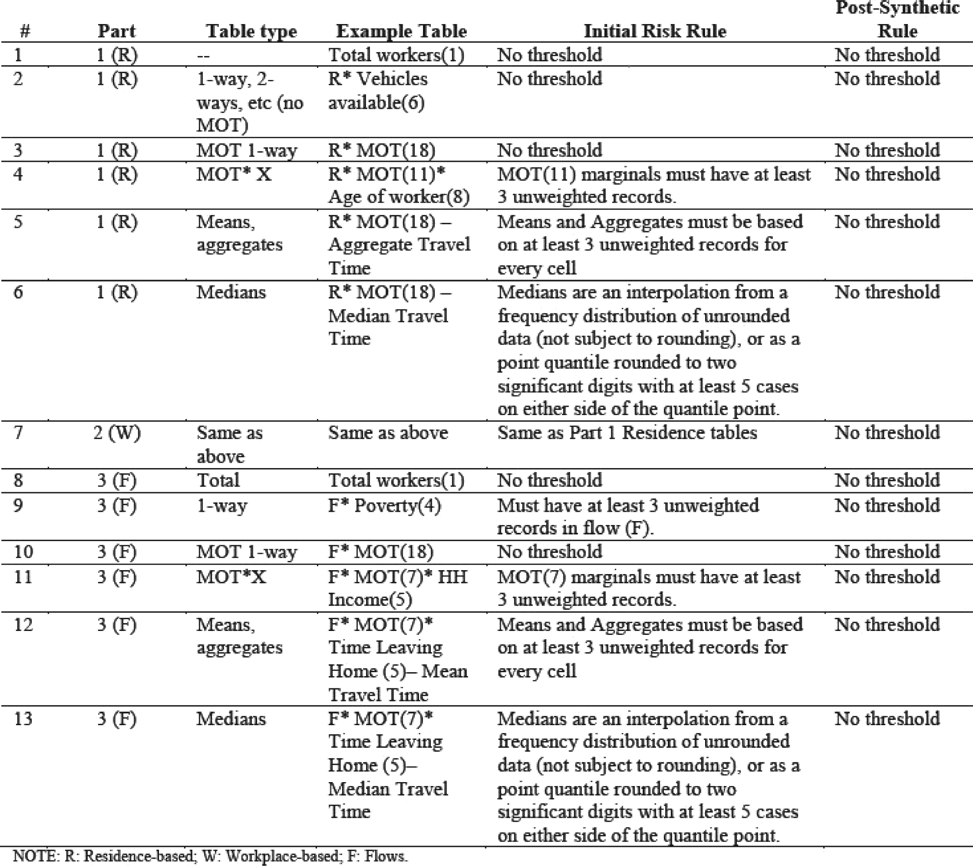
Source: Krenzke et al. 2011, Table 1.2. MOT = means of transportation.
Long Description.
The table has 6 columns and 13 rows. The columns include number, part, table type, example table, initial risk rule, and post-synthetic rule. Row details are as follows. Row 1. Number 1; Part 1 R; Table type, Nil; Example table, Total workers 1; Initial risk rule, No threshold; Post synthetic rule, No threshold. Row 2. Number 2; Part 1 R; Table type, 1 way, 2 ways, et cetera, no MOT; Example table, R star Vehicles available 6; Initial risk rule, No threshold; Post-synthetic rule, No threshold. Row 3. Number 3; Part 1 R; Table type MOT 1 way; Example table, R star MOT 18; Initial risk rule No threshold; Post-synthetic rule No threshold. Row 4. Number 4; Part 1 R; Table type MOT star X; Example table, R star MOT 11 star Age of worker 8; Initial risk rule, MOT 11 marginals must have at least 3 unweighted records; Post-synthetic rule, No threshold. Row 5. Number 5; Part 1 R; Table type Means, aggregates; Example table, R star MOT 18 Aggregate Travel Time; Initial risk rule, Means and aggregates must be based on at least 3 unweighted records for every cell; Post-synthetic rule, No threshold. Row 6. Number 6; Part 1 R; Table type Medians; Example table R star MOT 18 Median Travel Time; Initial risk rule, Medians are an interpolation from a frequency distribution of unrounded data not subject to rounding or as a point quantile rounded to two significant digits with at least 5 cases on either side of the quantile point; Post-synthetic rule, No threshold. Row 7. Number 7; Part 2 W; Table type, Same as above; Example table, Same as above; Initial risk rule, Same as Part 1 Residence tables; Post-synthetic rule, No threshold. Row 8. Number 8; Part 3 F; Table type, Total; Example table, Total workers 1; Initial risk rule, No threshold; Post-synthetic rule, No threshold. Row 9. Number 9; Part 3 F; Table type, 1-way; Example table, F star Poverty 4; Initial risk rule, Must have at least 3 unweighted records in flow F; Post-synthetic rule, No threshold. Row 10. Number 10; Part 3 F; Table type MOT 1 way; Example table, F star MOT 18; Initial risk rule, No threshold; Post-synthetic rule, No threshold. Row 11. Number 11; Part 3 F; Table type MOT star X; Example table, F star MOT 7 star H H Income 5; Initial risk rule, MOT 7 marginals must have at least 3 unweighted records; Post-synthetic rule, No threshold. Row 12. Number 12; Part 3 F; Table type, Means, aggregates; Example table, F star MOT 7 star Time Leaving Home 5 Mean Travel Time; Initial risk rule, Means and aggregates must be based on at least 3 unweighted records for every cell; Post-synthetic rule, No threshold. Row 13. Number 13; Part 3 F; Table type, Medians; Example table, F star MOT 7 star Time Leaving Home 5 Median Travel Time; Initial risk rule, Medians are an interpolation from a frequency distribution of unrounded data not subject to rounding or as a point quantile rounded to two significant digits with at least 5 cases on either side of the quantile point; Post-synthetic rule, No threshold.

Source: Faella 2018, Figure 3.1.
Long Description.
The table compares changes in CTPP tables between the 2006 to 2010 and 2012 to 2016 datasets. It includes five columns: number of 2006 to 2010 CTPP tables, number of tables deleted, number of tables retained at large geography only, number of all geography tables retained, and number of tables proposed for 2012 to 2016. Overall, 344 tables existed from 2006 to 2010. Of these, 176 were deleted, 76 retained for large geography only, 99 retained for all geography, and 168 proposed for 2012 to 2016. Part 1 Residence included 187 tables, 85 deleted, 48 retained at large geography, 56 retained for all geography, and 102 proposed. Part 2 Workplace included 116 tables, 73 deleted, 17 retained at large geography, 30 retained for all geography, and 43 proposed. Part 3 Flow included 41 tables, 18 deleted, 11 retained at large geography, 13 retained for all geography, and 23 proposed. The data reflects reductions and selective retention by geography type for the 2012 to 2016 period.
As stated previously, the ACTS program produces commute characteristics for the population broken across different universes:
- All persons
- All workers
- Persons in household
- Workers in households
- Workers not working at home.
For these different universes, commute characteristics as well as flow characteristics are available by various socioeconomic characteristics and commute mode. The complete list of tables and the associated geographies are available on the CTPP website (https://ctpp.transportation.org/wp-content/uploads/sites/57/2019/01/CTPP-tables-based-on-2012-2016-ACS_uploadedToWeb-2.xlsx).
3.3 Uses of CTPP Data
The CTPP data have been used for a variety of applications ranging from evaluating performance measures to factoring and adjusting surveys, and more recently to expanding and validating location-based services (LBS) data that are obtained via cell phone applications. A partial list of CTPP data applications is the following:
- Performance Measurement
- Modal Share Analysis
- FTA New Starts/Small Starts
- Travel Demand Modeling
- Policy Impact Analysis
- Livability Analysis
- Corridor Planning
- Air Quality Modeling
- Trend Analysis
- Descriptive Statistics
- Travel Forecasting
- Title VI
- Factoring/Adjusting Surveys
- Validating LBS estimates
The CTPP status reports released a couple of times per year are available at the FHWA ACTS program site, which provides various applications of CTPP data (https://www.fhwa.dot.gov/planning/census_issues/ctpp/status_report/). In addition, proceedings of a series of census data conferences held by TRB, FHWA, and AASHTO in 2005, 2011, and 2017 are available on the AASHTO ACTS program website (https://ctpp.transportation.org/).
3.4 CTPP Workplace Allocation Issues
The ACS questionnaire obtains a workerʼs workplace by having the worker/respondent provide their workplace name and address. The workplace information is then subjected to an extensive geocoding process within the Census Bureau. However, for many questionnaires, the workplace information is incomplete or otherwise cannot be geocoded. Therefore, not all workers can be geocoded to their exact work location. Internally, the Census Bureauʼs focus is to code every workerʼs workplace to at least a county and then allocate the maximum possible records to a place. From there, the workplaces are coded down through the geographic summary levels, with some records not making it to the next smaller area. For example, the total number of workers at work for all the counties in the 2012–2016 CTPP data is 145,769,040, while the total of workers at work for every census tract is 113,195,887. That is a loss of 32.6 million workers or 22 percent.
This discrepancy in total workers at these two levels—total U.S. workers versus the sum of workers for all census tracts—is a new phenomenon facing the current CTPP 2012–2016 dataset (released in April 2019). In preparing this dataset, the Census Bureau, for a variety of reasons, chose not to perform the extended allocation process. Extended allocation is an imputation process that assigns each worker to all levels of geography, even those records with missing or incomplete workplace addresses. Eliminating the extended allocation process from the CTPP 2012–2016 dataset represents a major change since extended allocation was used for the 2000 and the 2006–2010 CTPP (Limoges 2004, Rapino 2012).
Historically, the extended allocation process was developed from work done at the Southeast Michigan Council of Governments as a means to improve upon the allocation methods used by the Census Bureau for the 1980 and 1990 UTPP/CTPP datasets (Limoges 1997). For the UTPP 1980 dataset, the Census Bureau allocated all the workers to census tracts and TAZs. However, for the 1990 UTPP/CTPP dataset, a “remainder” area was created for the records that could not be allocated to the next smaller level of geography.
Over time, the extended allocation process continued to be enhanced but was only used for the CTPP datasets, not the standard Census Bureau datasets. It was always the hope of the transportation community to have extended allocation used on standard census datasets. After several DOT and joint DOT/Census Bureau research efforts, it looked like the extended allocation process would take root inside the Bureau.
However, after some additional research inside the Census Bureau, the extended allocation process was not adopted because it introduced more bias than was acceptable. The extended allocation process was officially canceled, and the ACTS Oversight Board decided that it would not be used for the 2012–2016 CTPP dataset or any others in the future. It should be noted that the workplace allocation issue has attracted a lot of attention in the transportation community, and research is currently being conducted on this topic.


