Ground Truth: Corona Landmarks (2019)
Chapter: Ground Truth: Corona Landmarks
|
CULTURAL |
An Exhibition by Julie Anand |
Ground Truth:
Corona Landmarks
Ground Truth: Corona Landmarks An Introduction
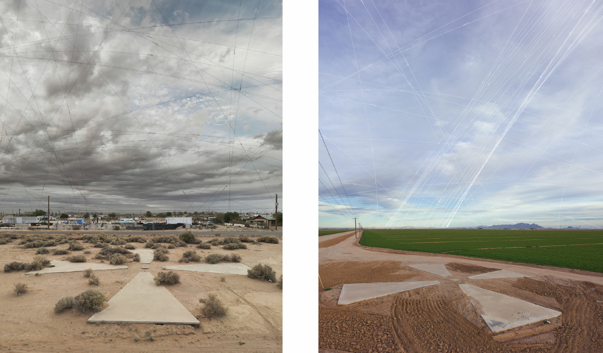
In this series of images of what remains of the Corona project, Julie Anand and Damon Sauer investigate our relationship to the vast networks of information that encircle the globe. The Corona project was a CIA and U.S. Air Force surveillance initiative that began in 1959 and ended in 1972. It involved using cameras on satellites to take aerial photographs of the Soviet Union and China. The cameras were calibrated with concrete targets on the ground that are 60 feet in diameter, which provided a reference for scale and ensured images were in focus.
Approximately 273 of these concrete targets were placed on a 16-square-mile grid in the Arizona desert, spaced a mile apart. Long after Corona’s end and its declassification in 1995, around 180 remain, and Anand and Sauer have spent three years photographing them as part of an ongoing project. In their images, each concrete target is overpowered by an expansive sky, onto which the artists map the paths of orbiting satellites that were present at the moment the photograph was taken. For Anand and Sauer, “these markers of space have become markers of time, representing a poignant moment in geopolitical and technologic social history.”
Anand and Sauer are artists and educators based in Phoenix, Arizona. Anand is currently associate professor in the School of Art at Arizona State University and Sauer serves as an assistant professor at the Art Institute of Pittsburgh—Online Division. Both received their MFA degrees in Photography from the University of New Mexico and began collaborating in 2005.
This exhibition is sponsored by Cultural Programs of the National Academy of Sciences
#CoronaLandmarks I @CPNAS

2016
archival pigment print
55 × 44 inches
A few of the calibration markers like this one are made primarily of rock rather than concrete. The artists hypothesize that it is because they were constructed at higher elevations and the weight of the materials, including water at 8 pounds per gallon, would be too labor intensive to transport. Only markers at higher elevations were built from rock. The artists like the way the rock references earlier civilizations’ rock formations which were also meant to be seen from the sky.
Cover page, left to right: Calibration Mark AE48 with Satellites, 2015, archival pigment print, 30 × 24 inches; Calibration Mark AM43 with Satellites, 2015, archival pigment print, 30 × 24 inches.

Seen here is an installation view of six large prints in the gallery. Each photo depicts one of the approximately 273 markers the US government installed in the Arizona desert and used to calibrate satellites photographing areas of the Soviet Union and China during the Cold War. It’s hard to imagine a world without Google maps or satellite imagery, but when the Corona project was developed in the 1950s, satellite photo-reconnaissance didn’t exist. During its operational life from 1959 to 1972, Corona collected over 800,000 photos. On average, each image covered a geographic area of the Earth’s surface of approximately 10 × 120 miles.
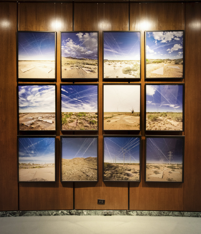
2. Calibration Mark AF49 with Satellites, 2015
3. Calibration Mark AD51 with Satellites, 2017
4. Calibration Mark AH49 with Satellites, 2015
5. Calibration Mark AD48 with Satellites, 2015
6. Calibration Mark AM48 with Satellites, 2015
7. Calibration Mark AJ46 with Satellites, 2015
8. Calibration Mark AE52 with Satellites, 2017
9. Calibration Mark AM50 with Satellites, 2017
10. Calibration Mark AF48 with Satellites, 2015
11. Calibration Mark AC47 with Satellites, 2015
12. Calibration Mark X47 with Satellites, 2015
archival pigment prints
30 × 24 inches each
These concrete markers are located in a 16-square-mile grid near Casa Grande, Arizona. The naming convention refers to their location in the desert, with letters referring to the column and numbers referring to the row. The markers were used to calibrate spy satellites during the Cold War in a secret program called Corona. In the expansive sky overhead in these images, Julie Anand and Damon Sauer have mapped all of the publicly known satellites in orbit at the moment the photo was taken. Anand and Sauer want viewers to think about the vast networks of information that encircle the globe.
Installation photos: Kevin Allen Photo
An Artful Archaeology of National Defense
By Ivan Amato
The Corona photoreconnaissance program was one of the most technologically sublime expressions of national Cold War angst. Declassified in 1995, the program, identified to the public under the cover name Discoverer, has been chronicled in books, documentaries, and museum exhibits. Artists now are enriching the Corona story by eliciting meaning with the help of their own telling lenses.
Authorized by President Eisenhower within one year of the Soviet Union’s late-1957, jab-in-the-fright-center, success with Sputnik 1—the world’s first artificial satellite—the joint CIA/Air Force Corona program began in 1960 to deliver intelligence of unprecedented extent and quality about Soviet air and missile assets. We should all still be grateful. This was the kind of sky-truth verification that gave national leadership the strength and confidence to sign arms-control treaties, which helped prevent the Cold War from becoming the world-ending hot war everybody feared.
Obtaining this intelligence required astonishingly capable cameras. It inspired the development of breakthrough film technology that could capture high-resolution imagery of many millions of square miles of territory from a short-lived satellite flying up to a hundred miles overhead at thousands of miles per hour. It required still nascent rocket booster technology, command-and-control capabilities, and techniques for placing the satellites into specific orbital trajectories, among many other engineering and procedural innovations.
Perhaps the most head-shaking feature of the Corona system was the James Bond-means of retrieving the film. While still in orbit, the satellites ejected one or more canisters containing reels of the exposed film. After a canister incandescently reentered the atmosphere and deployed its parachute, a military aircraft with a tethered snaring claw and winch would snatch the descending package in mid-air. The continuously upgraded Corona program lasted through 1972 by which time it had achieved 165 film recoveries (not always in midair) in its total of 145 launches. Some of Corona’s descendent technology is flying overhead as you read this essay.
There is nothing high-tech, high-flying, or audacious about the concrete, x-marks-the-spot calibration markers in Arizona’s Sonoran Desert that artists Julie Anand and Damon Sauer have captured in a photography series titled Ground Truth. In the Corona program, these 60-foot-diameter X-glyphs were arranged, allegedly with millimeter precision, one mile apart, most of them in a 16-mile by 16-mile grid. They served as photogrammetric markers that interpreters of the Corona film relied on to determine the sizes and separations of visible features, such as aircraft and missile complexes, in the snapshots captured over the Soviet Union and elsewhere. As such, these markers provided part of the ground truth for the otherwise harder-to-interpret overhead imagery. The principle is the same as walking close enough to a distant sign so that you can actually see and verify the words that you

2018
archival pigment print
55 × 44 inches
Notice the manhole cover set on the right edge of the marker. Every marker has one of these mysterious openings with a concrete lid. The holes are about three feet deep and the artists don’t yet know how they were used.
think you might have read from a distance.
With their portraits of some forty of the markers in their stark and lonely desert settings, Anand and Sauer hint of the ultimate fate of what is to come even of humanity’s most audacious feats of technological cleverness. Not even 70 years old, many of the markers already have taken steps toward a more thorough disintegration that one day will make them indiscernible from the desert settings in which Cold War contract employees constructed them. The artists showcase the markers’ status as Cold War archaeology. Like far more famous ruins in Egypt, Rome, and Central and South America, these fading ground-truth markers symbolize the transience of human touch and intention, no matter how grand.
At the same time, the photo series—both in the process of its making and in its final visual phenomenology—vogues a continuity connecting our present moment with our mid-twentieth-century relationship with technology and geopolitics. To produce the series, for one, the artists relied on photographic technology, albeit of a current generation with electronic “film” replacing the then high-tech polymer film that reeled through the Corona cameras. And by superimposing onto the sky of each photograph the trajectories of the many currently orbiting satellites soaring by overhead onto the desert sky as lines that form into a complex intersecting pattern, the artists connect the now fossilizing early phase of the space age with the still evolving current phase that has made the orbital environment a busy one. These images make me wonder what sorts of ground-truth calibration elements remain operative at various tucked-away places on the planet and how these elements too are fated to become archaeological hints of what also will become past technology.
By conducting current photographic reconnaissance of a come-and-gone technological system, Anand and Sauer intentionally expose a country’s urgent actions to detect and specify previously unknown intentions and capabilities of adversaries. At some of their photo shoots, the artists chose to record themselves in time-lapse photography as they undertook their work. Though it might not have been intentional, their self-recording reflects how we are voluntarily contributing to, and accelerating the arrival of, an era of ubiquitous surveillance. Perhaps one of the satellites passing overhead captured the artists in the act of recording themselves capturing a Cold War reconnaissance system slowly fading from view.

2018
archival pigment print
55 × 44 inches
Julie Anand notes, “We made this work after a rain so the mesquites and creosote are really green. We were excited about this marker because of the truly odd fence division running through it. What you can’t see from the picture because of the composition is that the fence is limited to just across the marker. It stops on both sides of the marker just out of frame. The markers fall on private property, open desert, farms, etc. This marker is on the edge of a Native American reservation. We haven’t photographed on the reservation yet because we have yet to negotiate permissions for photographing there. Approximately one third the markers we haven’t photographed are located on Native American land.”
2018
Archival pigment print
55 × 44 inches
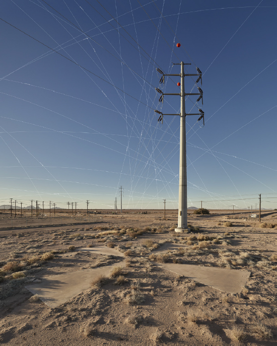
In this image, the power lines and the satellite orbits intersect—two overlapping human-made networks. The area in Arizona’s Sonoran desert where Julie Anand and Damon Sauer are photographing is rapidly changing from agricultural to suburban and many power lines are being installed.

2017
Archival pigment print
55 × 44 inches
There is great variation in the skies of Julie Anand and Damon Sauer’s images. During most of the year, clouds burn off by midday, giving way to a bright blue sky. It creates a contrasting background for the satellite orbit lines they add to the images later. Look closely, and you can see the names of the satellites that were orbiting in the sky at the moment Anand and Sauer took the photo. They took this photo in the summer, when it is so hot that they have to complete their field work before 8 a.m. when it hits around 100° Fahrenheit.


